Home > Arts > Artists > V > Sebastien Le Prestre de Vauban
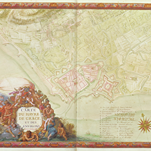
Ms. 986, Vol. 1 Plan and Map of Cambrai, from the Atlas Louis XIV, 1683-88

![]()
Wall Art and Photo Gifts from Fine Art Finder
Ms. 986, Vol. 1 Plan and Map of Cambrai, from the Atlas Louis XIV, 1683-88
XIR232101 Ms. 986, Vol.1 Plan and Map of Cambrai, from the Atlas Louis XIV, 1683-88 (gouache on paper) by Vauban, Sebastien Le Prestre de (1633-1707); Min. Defense - Service Historique de l Armee de Terre, France; French, out of copyright
Media ID 12766910
© www.bridgemanimages.com
Bastion Carte Fort Fortification Fortified City Star Shape
FEATURES IN THESE COLLECTIONS
> Arts
> Artists
> V
> Sebastien Le Prestre de Vauban
> Fine Art Finder
> Artists
> Sebastien Le Prestre de Vauban
> Fine Art Finder
> Maps (celestial & Terrestrial)
> Maps and Charts
> Star Charts
EDITORS COMMENTS
This print showcases the intricate and detailed "Ms. 986, Vol. 1 Plan and Map of Cambrai" from the renowned Atlas Louis XIV, dating back to 1683-88. Created by Sebastien Le Prestre de Vauban, a prominent military engineer during the reign of Louis XIV, this gouache on paper artwork offers a fascinating glimpse into the strategic planning and architectural brilliance of that era. The map depicts the fortified city of Cambrai in France, highlighting its impressive defense system with bastions arranged in a star shape formation. Every street, building, and wall is meticulously illustrated, providing an invaluable historical record of this significant town. Vauban's expertise in fortification design is evident in this masterpiece as he strategically planned each element to ensure maximum protection for Cambrai against potential invaders. The attention to detail exhibited here reflects his commitment to creating impenetrable defenses while maintaining aesthetic appeal. Preserved by the Ministry of Defense - Service Historique de l'Armee de Terre in France, this extraordinary piece represents not only an important part of French history but also serves as a testament to Vauban's enduring legacy as one of Europe's greatest military architects. Through this print captured by Fine Art Finder from bridgemanimages. com, viewers can appreciate both the artistic beauty and historical significance encapsulated within "Ms. 986 Vol. 1 Plan and Map of Cambrai". It stands as a remarkable tribute to Vauban's genius and provides us
MADE IN THE UK
Safe Shipping with 30 Day Money Back Guarantee
FREE PERSONALISATION*
We are proud to offer a range of customisation features including Personalised Captions, Color Filters and Picture Zoom Tools
SECURE PAYMENTS
We happily accept a wide range of payment options so you can pay for the things you need in the way that is most convenient for you
* Options may vary by product and licensing agreement. Zoomed Pictures can be adjusted in the Basket.