Home > Asia > Yemen > Maps
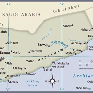
Manuscript Map of the Southern Portion of the Red Sea from the Horn of Africa

![]()
Wall Art and Photo Gifts from Fine Art Finder
Manuscript Map of the Southern Portion of the Red Sea from the Horn of Africa
828313 Manuscript Map of the Southern Portion of the Red Sea from the Horn of Africa and Yemen up to Jiddah, c.1740 (ink and wash on paper) by French School, (18th century); 52x72 cm; Private Collection; (add.info.: Manuscript Map of the Southern Portion of the Red Sea from the Horn of Africa and Yemen up to Jiddah. Depot de la Marine. Ink and wash on paper. Printed circa 1740. 52 x 72cm.); Photo eChristies Images; French, out of copyright
Media ID 22224684
© Christie's Images / Bridgeman Images
1740 1740s Geographic Hand Writing Hand Written In Ink Ink Drawing Language Lettering Mid 18th Century Mid Eighteenth Century Mounted On Paper Navigational Equipment On Paper Part Of Portion Red Sea Southern Topographical Paintings Wash Word Yemen Horn Of Africa Jiddah Natural Space
FEATURES IN THESE COLLECTIONS
> Africa
> Related Images
> Arts
> Artists
> Related Images
> Fine Art Finder
> Artists
> French School
> Fine Art Finder
> Artists
> School Chinese
> Fine Art Finder
> Temp Classification
EDITORS COMMENTS
This print showcases a Manuscript Map of the Southern Portion of the Red Sea from the Horn of Africa and Yemen up to Jiddah. Created by an anonymous French School artist in the 18th century, this ink and wash on paper masterpiece measures 52x72 cm and is currently held in a private collection. The map, which was printed around 1740, offers an intricate depiction of the southern region of the Red Sea. It was originally part of Depot de la Marine's navigational equipment, serving as a crucial tool for sailors exploring these treacherous waters. The detailed drawing includes topographical paintings, geographical features, and waterways essential for safe navigation. What makes this manuscript truly remarkable is its handwritten annotations in elegant lettering. These carefully crafted words provide additional information about specific locations along with other relevant details related to sea routes and coastal areas. The close-up view allows us to appreciate every stroke made with ink and wash on paper. The delicate lines create a visual language that speaks volumes about the skillful craftsmanship employed during this period. Transport yourself back to mid-18th century exploration as you immerse yourself in this fascinating piece of history. With no people present within its frame, it invites viewers to ponder upon ancient voyages while marveling at both its artistic beauty and practical purpose.
MADE IN THE UK
Safe Shipping with 30 Day Money Back Guarantee
FREE PERSONALISATION*
We are proud to offer a range of customisation features including Personalised Captions, Color Filters and Picture Zoom Tools
SECURE PAYMENTS
We happily accept a wide range of payment options so you can pay for the things you need in the way that is most convenient for you
* Options may vary by product and licensing agreement. Zoomed Pictures can be adjusted in the Basket.