Home > Europe > United Kingdom > England > London > Museums > National Maritime Museum
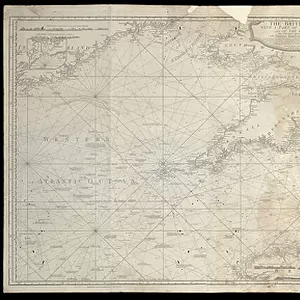
Map of South East England, 1738 (print)
")
![]()
Wall Art and Photo Gifts from Fine Art Finder
Map of South East England, 1738 (print)
7340691 Map of South East England, 1738 (print) by Whiston, William (18th century); National Maritime Museum, London, UK; (add.info.: Creator: William Whiston
A map from 'The Longitude Discovered' by William Whiston depicting the limits of viewing the flash from a mortar fired at Shooter's Hill, near Greenwich.); © National Maritime Museum, Greenwich, London
Media ID 38372272
© © National Maritime Museum, Greenwich, London / Bridgeman Images
FEATURES IN THESE COLLECTIONS
> Arts
> Artists
> I
> William Ireland
> Arts
> Artists
> W
> William White
> Europe
> Republic of Ireland
> Maps
> Europe
> United Kingdom
> England
> London
> Boroughs
> Greenwich
> Europe
> United Kingdom
> England
> London
> Museums
> British Museum
> Europe
> United Kingdom
> England
> London
> Museums
> Greenwich Heritage Centre
> Europe
> United Kingdom
> England
> London
> Museums
> National Maritime Museum
> Europe
> United Kingdom
> England
> London
> Sights
> British Museum
> Europe
> United Kingdom
> England
> London
> Towns
> Greenwich
> Europe
> United Kingdom
> England
> Maps
> Fine Art Finder
> Artists
> Robert Sayer
EDITORS COMMENTS
This stunning print of a Map of South East England from 1738 by William Whiston offers a fascinating glimpse into the past. The intricate details and precise cartography on display showcase the skill and artistry of mapmaking in the 18th century.
The map, featured in 'The Longitude Discovered' by Whiston, highlights the limits of viewing the flash from a mortar fired at Shooter's Hill near Greenwich. This historical document not only serves as a navigational tool but also provides valuable insights into scientific advancements and technological innovations of the time.
As you study this black-and-white image, you can almost feel yourself transported back to early 18th century England. The meticulous attention to detail in depicting towns, rivers, and landmarks gives us a sense of how people navigated their world centuries ago.
From London to Brighton, Canterbury to Oxford, every inch of this map tells a story about the rich history and cultural heritage of South East England. It is truly a work of art that captures both the beauty and complexity of cartography in its golden age.
This print from Bridgeman Images is not just an ordinary map – it is a window into another era, inviting us to explore and appreciate the wonders of our past.
MADE IN THE UK
Safe Shipping with 30 Day Money Back Guarantee
FREE PERSONALISATION*
We are proud to offer a range of customisation features including Personalised Captions, Color Filters and Picture Zoom Tools
SECURE PAYMENTS
We happily accept a wide range of payment options so you can pay for the things you need in the way that is most convenient for you
* Options may vary by product and licensing agreement. Zoomed Pictures can be adjusted in the Basket.