Home > Arts > Artists > Peter Paul Rubens > Historical events depicted in art
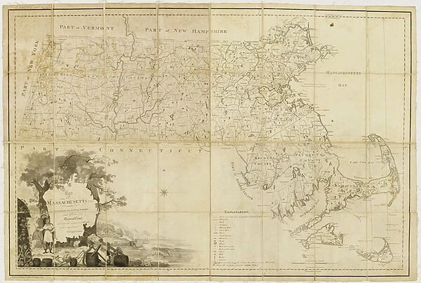
Map of Massachusetts proper: compiled from actual surveys made by order of the General
![]()

Wall Art and Photo Gifts from Fine Art Finder
Map of Massachusetts proper: compiled from actual surveys made by order of the General
5905725 Map of Massachusetts proper: compiled from actual surveys made by order of the General Court and under the inspection of agents of their appointment, 1802 (engraving) by Carleton, Osgood (1742-1816); 79x116 cm; Massachusetts Historical Society, Boston, MA, USA; (add.info.: Engraved by:
Callender, Joseph, 1751-1821.
Hill, Samuel, 1766?-1804.); eMassachusetts Historical Society; American, out of copyright
Media ID 23261546
© Massachusetts Historical Society / Bridgeman Images
1800s Mapping Massachusetts New England State
FEATURES IN THESE COLLECTIONS
> Arts
> Artists
> Peter Paul Rubens
> Historical events depicted in art
> Arts
> Artists
> Peter Paul Rubens
> Arts
> Artists
> R
> Peter Paul Rubens
> Europe
> United Kingdom
> England
> Maps
> Fine Art Finder
> Artists
> Peter Paul Rubens
> Maps and Charts
> Early Maps
> North America
> United States of America
> Maps
> North America
> United States of America
> Massachusetts
> Boston
EDITORS COMMENTS
This print showcases the remarkable "Map of Massachusetts proper: compiled from actual surveys made by order of the General Court and under the inspection of agents of their appointment, 1802". Crafted with meticulous detail and precision, this engraving by Carleton Osgood in collaboration with Joseph Callender and Samuel Hill offers a fascinating glimpse into the historical landscape of Massachusetts. Measuring an impressive 79x116 cm, this map is a testament to the artistry and dedication involved in cartography during that era. It serves as a valuable resource for historians, researchers, and enthusiasts alike who seek to explore the rich history embedded within Massachusetts' borders. The intricate lines etched on this map depict not only geographical features but also provide insights into settlements, roads, rivers, and other significant landmarks. As we gaze upon it today, we are transported back to early 19th-century America when exploration was at its peak. Preserved by the Massachusetts Historical Society in Boston, MA. , this print captures an important piece of American heritage. Its presence reminds us of how far we have come while honoring those who meticulously surveyed these lands centuries ago. Whether you are fascinated by maps or simply intrigued by history's unfolding stories, this print is sure to captivate your imagination. Let it transport you through time as you delve into the intricacies woven within every inch of its carefully crafted design.
MADE IN THE UK
Safe Shipping with 30 Day Money Back Guarantee
FREE PERSONALISATION*
We are proud to offer a range of customisation features including Personalised Captions, Color Filters and Picture Zoom Tools
SECURE PAYMENTS
We happily accept a wide range of payment options so you can pay for the things you need in the way that is most convenient for you
* Options may vary by product and licensing agreement. Zoomed Pictures can be adjusted in the Basket.

