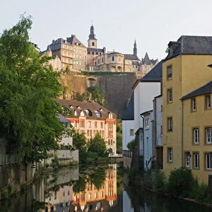
Home > Europe > Luxembourg > Heritage Sites > City of Luxembourg: its Old Quarters
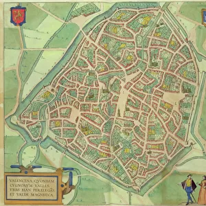
Map of Luxembourg, from Civitates Orbis Terrarum

![]()
Wall Art and Photo Gifts from Fine Art Finder
Map of Luxembourg, from Civitates Orbis Terrarum
STC138913 Map of Luxembourg, from Civitates Orbis Terrarum by Georg Braun (1541-1622) and Frans Hogenberg (1535-90) c.1572-1617 (coloured engraving) by Hoefnagel, Joris (1542-1600) (after); Private Collection; The Stapleton Collection; Flemish, out of copyright
Media ID 23354708
© The Stapleton Collection / Bridgeman Images
Atlas Birds Eye View Cities Of The World Crest River Alzette
FEATURES IN THESE COLLECTIONS
> Arts
> Artists
> Related Images
> Arts
> Landscape paintings
> Waterfall and river artworks
> River artworks
> Europe
> Luxembourg
> Heritage Sites
> City of Luxembourg: its Old Quarters
> Europe
> Luxembourg
> Maps
> Europe
> Luxembourg
> Rivers
> Fine Art Finder
> Artists
> Joris (after) Hoefnagel
> Fine Art Finder
> Maps (celestial & Terrestrial)
> Maps and Charts
> Luxembourg
> Maps and Charts
> World
EDITORS COMMENTS
This print showcases a remarkable piece of history - the Map of Luxembourg, from Civitates Orbis Terrarum. Created by Georg Braun and Frans Hogenberg in the late 16th century, this coloured engraving offers a mesmerizing birds-eye view of Luxembourg City. The intricate details captured in this map transport us back to an era long gone, allowing us to explore the city as it stood centuries ago. The coat of arms proudly displayed on the map reminds us of the rich heritage and noble lineage that Luxembourg holds. As we gaze upon this enchanting print, our eyes are drawn to the meandering River Alzette that gracefully winds its way through the cityscape. Its presence serves as a reminder of nature's harmonious integration with urban life during that time. Joris Hoefnagel skillfully recreated this masterpiece through his own artistic lens, paying homage to Braun and Hogenberg's original work. This engraving is not just an atlas or mere representation; it is a testament to human ingenuity and exploration. The Fine Art Finder has preserved this extraordinary image for all art enthusiasts to appreciate. It invites us into a world where maps were meticulously crafted by hand, offering both practical guidance and aesthetic pleasure. Let your imagination wander as you delve into this historical gem brought forth by Bridgeman Images' collection - truly a treasure worth cherishing for generations to come.
MADE IN THE UK
Safe Shipping with 30 Day Money Back Guarantee
FREE PERSONALISATION*
We are proud to offer a range of customisation features including Personalised Captions, Color Filters and Picture Zoom Tools
SECURE PAYMENTS
We happily accept a wide range of payment options so you can pay for the things you need in the way that is most convenient for you
* Options may vary by product and licensing agreement. Zoomed Pictures can be adjusted in the Basket.