Home > Animals > Mammals > Elephantidae > African Elephant
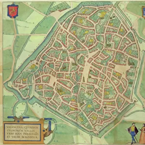
Map of Calicut, from Civitates Orbis Terrarum by Georg Braun (1541-1622

![]()
Wall Art and Photo Gifts from Fine Art Finder
Map of Calicut, from Civitates Orbis Terrarum by Georg Braun (1541-1622
STC121079 Map of Calicut, from Civitates Orbis Terrarum by Georg Braun (1541-1622) and Frans Hogenberg (1535-90), c.1572 (coloured engraving) by Hoefnagel, Joris (1542-1600) (after); Private Collection; (add.info.: Portuguese ports on the way to the Orient;
Calechut (modern day Kozikhode) on Kerala coast, south of Goa;
Hormuz on the Persian Gulf, Iran; Cannanore is a port on the coast of northern Malabar;
St George el Mina is a fort and mining town in Guinea; ); The Stapleton Collection; Flemish, out of copyright
Media ID 22217198
© The Stapleton Collection / Bridgeman Images
Aerial View Atlantic Boat Building Cities Of The World Elephant Far East Fort Galleon Ghana Gold Coast Guinea Gulf Iran Kerala Merchants Mine Mining Moorish Persia Portugal Portuguese St George Trading Trading Post El Mina Ghanian Mina
FEATURES IN THESE COLLECTIONS
> Aerial Photography
> Portugal
> Animals
> Mammals
> African Elephant
> Animals
> Mammals
> Elephantidae
> African Elephant
> Arts
> Artists
> Related Images
> Fine Art Finder
> Artists
> Joris (after) Hoefnagel
> Fine Art Finder
> Maps (celestial & Terrestrial)
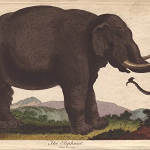
EDITORS COMMENTS
This print showcases a beautifully detailed "Map of Calicut" from the renowned Civitates Orbis Terrarum by Georg Braun and Frans Hogenberg. Created in 1572, this colored engraving offers a fascinating glimpse into the Portuguese ports on their way to the Orient. The map highlights various significant locations such as Calechut (modern-day Kozikhode) along the Kerala coast, south of Goa. It also features Hormuz, an important port situated on the Persian Gulf in Iran. Additionally, Cannanore is depicted as a bustling port on the northern Malabar coast. One cannot miss St George el Mina, an impressive fort and mining town located in Guinea. The aerial view captures its grandeur amidst lush surroundings. This map serves as a testament to the extensive trading network established by European merchants during that era. The intricate details include ships and galleons sailing across vast oceans, symbolizing trade routes between continents. The presence of castles and fortresses signifies strategic strongholds for these trading posts. From Africa's Gold Coast to India's coastal regions, this map illustrates how commerce flourished across diverse landscapes. Moorish influences are evident through depictions of elephants and gold mines scattered throughout. Overall, this historic piece provides valuable insights into early maritime exploration and trade connections between Europe, Asia, Africa, and beyond. Its meticulous engravings make it not just an informative document but also a work of art worth admiring for its beauty and historical significance.
MADE IN THE UK
Safe Shipping with 30 Day Money Back Guarantee
FREE PERSONALISATION*
We are proud to offer a range of customisation features including Personalised Captions, Color Filters and Picture Zoom Tools
SECURE PAYMENTS
We happily accept a wide range of payment options so you can pay for the things you need in the way that is most convenient for you
* Options may vary by product and licensing agreement. Zoomed Pictures can be adjusted in the Basket.