Home > Europe > United Kingdom > England > London > Politics > John Stuart
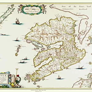
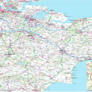
Kent, engraved by Jodocus Hondius (1563-1612) from John Speeds Theatre of the
 from John Speeds Theatre of the")
![]()
Wall Art and Photo Gifts from Fine Art Finder
Kent, engraved by Jodocus Hondius (1563-1612) from John Speeds Theatre of the
XCF306016 Kent, engraved by Jodocus Hondius (1563-1612) from John Speeds Theatre of the Empire of Great Britain, pub. by John Sudbury and George Humble, 1611-12 (hand- coloured copper engraving) by Speed, John (1552-1629) (after); Private Collection; English, out of copyright
Media ID 12840922
© www.bridgemanart.com
Borders Canterbury Compass County Crest English Channel Geographical Mapping North Sea Rochester Stuart
FEATURES IN THESE COLLECTIONS
> Arts
> Artists
> H
> Jodocus Hondius
> Arts
> Artists
> S
> John Speed
> Europe
> United Kingdom
> England
> Canterbury
> Europe
> United Kingdom
> England
> Kent
> Canterbury
> Europe
> United Kingdom
> England
> Kent
> Related Images
> Europe
> United Kingdom
> England
> Kent
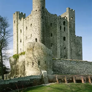
> Rochester
> Europe
> United Kingdom
> England
> London
> Politics
> John Stuart
> Europe
> United Kingdom
> England
> Maps
> Fine Art Finder
> Artists
> John (after) Speed
> Maps and Charts
> British Empire Maps
EDITORS COMMENTS
This print showcases a remarkable piece of cartographic history - an engraved map of Kent, skillfully crafted by Jodocus Hondius and published in John Speed's renowned Theatre of the Empire of Great Britain. Created between 1611-12, this hand-colored copper engraving is a true testament to the artistry and precision involved in early map-making. Every intricate detail comes to life in this stunning print, revealing the county's diverse landscape with its towns, cities, and coat of arms elegantly displayed. The compass rose at the center serves as a navigational guide while adding aesthetic charm to the composition. From Rochester to Canterbury, every town is meticulously depicted with utmost accuracy. As we explore this historical gem further, our eyes are drawn towards the surrounding bodies of water - the English Channel and North Sea - reminding us of Kent's strategic coastal location. This map not only serves as a geographical reference but also offers insights into England's rich maritime heritage during the Stuart era. With its vibrant colors and exquisite craftsmanship preserved through time, this print transports us back to seventeenth-century England. It invites us to appreciate both the artistic mastery behind such maps and their invaluable contribution to our understanding of geography throughout history.
MADE IN THE UK
Safe Shipping with 30 Day Money Back Guarantee
FREE PERSONALISATION*
We are proud to offer a range of customisation features including Personalised Captions, Color Filters and Picture Zoom Tools
SECURE PAYMENTS
We happily accept a wide range of payment options so you can pay for the things you need in the way that is most convenient for you
* Options may vary by product and licensing agreement. Zoomed Pictures can be adjusted in the Basket.