Home > Europe > United Kingdom > England > London > Museums > National Maritime Museum
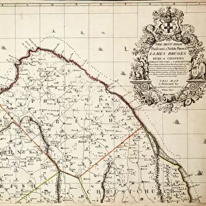
A new & exact map of the island of Barbados in America according to survey made in the years 1717 to 1721 by William Mayo, 1722 (technical drawing)
")
![]()
Wall Art and Photo Gifts from Fine Art Finder
A new & exact map of the island of Barbados in America according to survey made in the years 1717 to 1721 by William Mayo, 1722 (technical drawing)
7295398 A new & exact map of the island of Barbados in America according to survey made in the years 1717 to 1721 by William Mayo, 1722 (technical drawing) by Senex, John (1678-1740); 47x56 cm; National Maritime Museum, London, UK; (add.info.: Creator: William Mayo; John Senex); © National Maritime Museum, Greenwich, London
Media ID 38176486
© © National Maritime Museum, Greenwich, London / Bridgeman Images
18e Siecle 18th Century 18th Centuries Art (fine Art) Barbados Caribbean Cartography Etats Unis Etats Unis Usa United States Isles
FEATURES IN THESE COLLECTIONS
> Animals
> Mammals
> Sciuridae
> Senex
> Arts
> Artists
> S
> John Senex
> Europe
> United Kingdom
> England
> London
> Boroughs
> Greenwich
> Europe
> United Kingdom
> England
> London
> Museums
> Greenwich Heritage Centre
> Europe
> United Kingdom
> England
> London
> Museums
> National Maritime Museum
> Europe
> United Kingdom
> England
> London
> Towns
> Greenwich
> Europe
> United Kingdom
> Heritage Sites
> Maritime Greenwich
> Europe
> United Kingdom
> Maps
> Fine Art Finder
> Artists
> Joannes Jansson
> Fine Art Finder
> Artists
> John Senex
> Maps and Charts
> Early Maps
EDITORS COMMENTS
This stunning technical drawing, created by William Mayo and John Senex in the early 18th century, showcases a new and exact map of the island of Barbados in America. The intricate details and vibrant colors bring this historical piece to life, offering a glimpse into the cartography of the time.
Measuring 47x56 cm, this map is a true work of art that captures the beauty and complexity of Barbados. From its lush landscapes to its coastal shores, every aspect of the island is meticulously depicted with precision and care.
As you study this map closely, you can almost imagine yourself exploring the streets and villages of Barbados during the 18th century. The attention to detail in each stroke and line speaks to the skill and dedication of both Mayo and Senex in creating such an accurate representation.
Displayed at the National Maritime Museum in London, UK, this piece serves as a reminder of our rich history and connection to places like Barbados. It is not just a map but a window into another time, inviting us to learn more about this beautiful island nation in America.
Let this print transport you back in time as you marvel at its beauty and intricacy, appreciating the artistry behind every stroke.
MADE IN THE UK
Safe Shipping with 30 Day Money Back Guarantee
FREE PERSONALISATION*
We are proud to offer a range of customisation features including Personalised Captions, Color Filters and Picture Zoom Tools
SECURE PAYMENTS
We happily accept a wide range of payment options so you can pay for the things you need in the way that is most convenient for you
* Options may vary by product and licensing agreement. Zoomed Pictures can be adjusted in the Basket.