Home > Fine Art Finder > Artists > Jacopo Russo
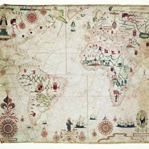
Ms Ital 550. 0. 3. 15 fol. 2r Map of Europe, from Carte Geografiche (vellum)
")
![]()
Wall Art and Photo Gifts from Fine Art Finder
Ms Ital 550. 0. 3. 15 fol. 2r Map of Europe, from Carte Geografiche (vellum)
XAL249430 Ms Ital 550.0.3.15 fol.2r Map of Europe, from Carte Geografiche (vellum) by Russo, Jacopo (15th century); Biblioteca Estense, Modena, Italy; Italian, out of copyright
Media ID 12770973
© www.bridgemanart.com
EDITORS COMMENTS
This print showcases a remarkable piece of history, the "Ms Ital 550.0.3.15 fol. 2r Map of Europe" by Jacopo Russo from the 15th century. Housed in the Biblioteca Estense in Modena, Italy, this vellum map offers a fascinating glimpse into medieval cartography. The intricate details and craftsmanship evident in this artwork are truly awe-inspiring. Spanning across the page, we can see various countries and regions meticulously depicted – Great Britain, England, Ireland, France, Spain – each with its own distinct characteristics and borders. What makes this map even more intriguing is the presence of a compass rose at its center. This symbolizes not only navigational tools but also an era when exploration and discovery were highly valued endeavors. As we delve into this historical artifact through our modern lens, it serves as a reminder of how far we have come in terms of geographical knowledge and technological advancements. It allows us to appreciate both the artistry involved in creating such maps during that time period and their significance as valuable sources of information for travelers. Through this print provided by Fine Art Finder via www. bridgemanart. com, we are granted access to an extraordinary relic from centuries past – one that invites us to explore Europe's rich history while marveling at the skillful craftsmanship behind its creation.
MADE IN THE UK
Safe Shipping with 30 Day Money Back Guarantee
FREE PERSONALISATION*
We are proud to offer a range of customisation features including Personalised Captions, Color Filters and Picture Zoom Tools
SECURE PAYMENTS
We happily accept a wide range of payment options so you can pay for the things you need in the way that is most convenient for you
* Options may vary by product and licensing agreement. Zoomed Pictures can be adjusted in the Basket.