Home > Europe > France > Canton > Ille
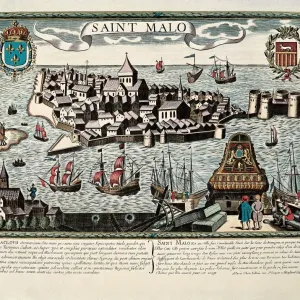
Saintonge with La Rochelle and Ile Oleron, France (engraving, 1596)
")
![]()
Wall Art and Photo Gifts from Fine Art Finder
Saintonge with La Rochelle and Ile Oleron, France (engraving, 1596)
LRI4717187 Saintonge with La Rochelle and Ile Oleron, France (engraving, 1596) by Mercator, Gerardus (1512-94); Private Collection; (add.info.: Map of the pais of Xaintonge, 1655: Xaintonge with La Rochelle and Ille Oleron, France - in " Atlas Ssive Corsmographicae Meditationes" by Gerard Mercator (Gerard de Kremer - Gerhard Kremer - Gerardus Mercator) (1512-1594), Duisburg 1596); Luisa Ricciarini; Flemish, out of copyright
Media ID 23718010
© Luisa Ricciarini / Bridgeman Images
Aquitaine Atlas Book Charente Maritime 17 Geographical Map
FEATURES IN THESE COLLECTIONS
> Arts
> Artists
> M
> Gerardus Mercator
> Europe
> France
> Canton
> Charente
> Europe
> France
> Canton
> Ille
> Fine Art Finder
> Artists
> Gerardus Mercator
> Maps and Charts
> Gerardus Mercator's Cartographic
EDITORS COMMENTS
This engraving, titled "Saintonge with La Rochelle and Ile Oleron, France" takes us back in time to the year 1596. Created by the renowned cartographer Gerardus Mercator, this intricate map showcases the picturesque region of Saintonge along with its prominent landmarks. The print depicts a detailed representation of the landscape, highlighting the charming town of La Rochelle and the enchanting Ile Oleron. The delicate lines and precise details bring life to this historical masterpiece, allowing viewers to immerse themselves in the beauty of 16th-century France. As we gaze upon this ancient map from Mercator's "Atlas Ssive Corsmographicae Meditationes" we are transported to a world where exploration was at its peak. This work not only serves as a geographical reference but also provides insight into how people perceived their surroundings during that era. Preserved within a private collection, this engraving is a testament to Mercator's exceptional talent and his contribution to cartography. Its inclusion in Luisa Ricciarini's portfolio further emphasizes its significance as an artistic treasure. Whether you are an avid history enthusiast or simply appreciate fine art, this print offers a glimpse into both past landscapes and artistic mastery. It invites us on a journey through time while reminding us of the enduring power of maps as windows into our world's rich history.
MADE IN THE UK
Safe Shipping with 30 Day Money Back Guarantee
FREE PERSONALISATION*
We are proud to offer a range of customisation features including Personalised Captions, Color Filters and Picture Zoom Tools
SECURE PAYMENTS
We happily accept a wide range of payment options so you can pay for the things you need in the way that is most convenient for you
* Options may vary by product and licensing agreement. Zoomed Pictures can be adjusted in the Basket.