Home > Arts > Artists > B > Willem Blaeu
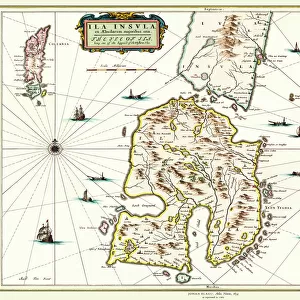
Geography map: representation of the region of Virginia where the Powhatans Indians lived in North America from an Atlas from the melted workshops by the cartographer Willem Janszoon Blaeu (1571-1638), 17th century Biblioteca Angelica, Rome
, 17th century Biblioteca Angelica, Rome")
![]()
Wall Art and Photo Gifts from Fine Art Finder
Geography map: representation of the region of Virginia where the Powhatans Indians lived in North America from an Atlas from the melted workshops by the cartographer Willem Janszoon Blaeu (1571-1638), 17th century Biblioteca Angelica, Rome
VEN5030339 Geography map: representation of the region of Virginia where the Powhatans Indians lived in North America from an Atlas from the melted workshops by the cartographer Willem Janszoon Blaeu (1571-1638), 17th century Biblioteca Angelica, Rome; (add.info.: Geography map: representation of the region of Virginia where the Powhatans Indians lived in North America from an Atlas from the melted workshops by the cartographer Willem Janszoon Blaeu (1571-1638), 17th century Biblioteca Angelica, Rome); © Marage Photos
Media ID 38350284
© © Marage Photos / Bridgeman Images
17eme Siecle Amerique (continent) Amerique Du Nord Carte Geographique Etats Unis Etats Unis Damèrique Geographie Stockravenna
FEATURES IN THESE COLLECTIONS
> Arts
> Artists
> B
> Willem Blaeu
> Fine Art Finder
> Artists
> Francois Xavier Fabre
> Maps and Charts
> Early Maps
> North America
> United States of America
> Maps
> North America
> United States of America
> Virginia
> Related Images
EDITORS COMMENTS
This stunning geography map from the 17th century showcases the region of Virginia where the Powhatan Indians lived in North America. Created by the renowned cartographer Willem Janszoon Blaeu, this intricate representation is a true work of art.
The detailed craftsmanship and accuracy of this map provide valuable insight into the geographical knowledge of that time period. It serves as a historical record of not only the land itself but also the indigenous people who called it home.
As we study this map, we are transported back in time to an era when exploration and discovery were at the forefront of human endeavor. The delicate engravings and careful attention to detail speak to the dedication and skill of Blaeu as a cartographer.
Displayed in Biblioteca Angelica in Rome, this piece is a testament to both European exploration and Native American history. It reminds us of the complex interactions between different cultures and societies during this pivotal period in history.
Overall, this geography map is not just a visual representation of landmasses and borders; it is a window into our collective past. It invites us to explore, learn, and appreciate the rich tapestry of human experience that has shaped our world today.
MADE IN THE UK
Safe Shipping with 30 Day Money Back Guarantee
FREE PERSONALISATION*
We are proud to offer a range of customisation features including Personalised Captions, Color Filters and Picture Zoom Tools
SECURE PAYMENTS
We happily accept a wide range of payment options so you can pay for the things you need in the way that is most convenient for you
* Options may vary by product and licensing agreement. Zoomed Pictures can be adjusted in the Basket.