Home > Africa > Ethiopia > Related Images
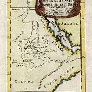
Map of Ethiopia showing five African states, c.1690 possibly after G. Blaeu's "Grooten Atlas" of 1648-65

![]()
Wall Art and Photo Gifts from Fine Art Finder
Map of Ethiopia showing five African states, c.1690 possibly after G. Blaeu's "Grooten Atlas" of 1648-65
BAL42830 Map of Ethiopia showing five African states, c.1690 possibly after G. Blaeu's "Grooten Atlas" of 1648-65; O'Shea Gallery, London, UK
Media ID 38064658
© Bridgeman Images
Abyssinia Congo Mozambique Nubia
FEATURES IN THESE COLLECTIONS
> Africa
> Ethiopia (Abyssinia)
> Maps
> Africa
> Ethiopia (Abyssinia)
> Related Images
> Africa
> Ethiopia
> Related Images
> Africa
> Mozambique
> Maps
> Africa
> Mozambique
> Related Images
> Europe
> United Kingdom
> Maps
> Fine Art Finder
> Artists
> Edmund Dulac
> Fine Art Finder
> Maps (celestial & Terrestrial)
EDITORS COMMENTS
This stunning print captures a historic Map of Ethiopia dating back to around 1690, possibly inspired by G. Blaeu's renowned "Grooten Atlas" from the mid-17th century. The intricate details and vibrant colors of this map showcase five African states - Congo, Abyssinia, Biafra, Nubia, and Mozambique - each with its own unique borders and characteristics.
As you gaze upon this piece of art, you can't help but be transported back in time to an era when cartography was as much an art form as it was a science. The precision and craftsmanship that went into creating maps like these are truly awe-inspiring.
The Map of Ethiopia serves not only as a geographical representation but also as a historical document that sheds light on the political landscape of Africa during this period. It offers a glimpse into the diverse cultures and territories that existed long before modern boundaries were drawn.
Whether you're a history buff or simply appreciate the beauty of antique maps, this print is sure to captivate your imagination and spark curiosity about the rich heritage of the African continent. Display it proudly in your home or office to add a touch of sophistication and intrigue to any space.
MADE IN THE UK
Safe Shipping with 30 Day Money Back Guarantee
FREE PERSONALISATION*
We are proud to offer a range of customisation features including Personalised Captions, Color Filters and Picture Zoom Tools
SECURE PAYMENTS
We happily accept a wide range of payment options so you can pay for the things you need in the way that is most convenient for you
* Options may vary by product and licensing agreement. Zoomed Pictures can be adjusted in the Basket.