Home > Arts > Artists > M > Edmond Morin
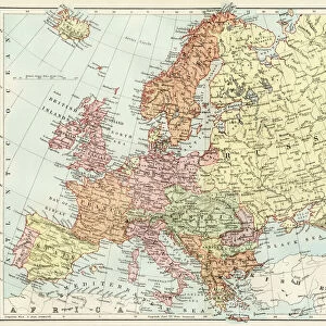
Map showing the New Frontier Line between Russia and Turkey as settled by the Treaty, 30 March 1856 (engraving)
![]()

Wall Art and Photo Gifts from Fine Art Finder
Map showing the New Frontier Line between Russia and Turkey as settled by the Treaty, 30 March 1856 (engraving)
1608808 Map showing the New Frontier Line between Russia and Turkey as settled by the Treaty, 30 March 1856 (engraving) by Dower, John (fl.c.1845-55); Private Collection; (add.info.: Map showing the New Frontier Line between Russia and Turkey as settled by the Treaty, 30 March 1856. Illustration for The Illustrated London News, 17 May 1856.
John Dower); Look and Learn / Illustrated Papers Collection
Media ID 22558060
© Look and Learn / Illustrated Papers Collection / Bridgeman Images
Borders Central Turkey Settled Showing Treaty Turkish Culture Turk
FEATURES IN THESE COLLECTIONS
> Arts
> Artists
> M
> Edmond Morin
> Asia
> Turkey
> Related Images
> Fine Art Finder
> Artists
> Edmond Morin
> Fine Art Finder
> Artists
> John Dower
EDITORS COMMENTS
This engraving, titled "Map showing the New Frontier Line between Russia and Turkey as settled by the Treaty, 30 March 1856" takes us back to a significant moment in history. Created by John Dower, this map was originally published in The Illustrated London News on May 17th, 1856. The image showcases the intricate borders that were established between Russia and Turkey following the signing of a crucial treaty on March 30th of that same year. It provides a detailed depiction of Europe's eastern frontier line, marking an important milestone in diplomatic relations during this era. As we examine this historical artifact, we are transported to a time when tensions ran high between these two nations. The map highlights not only political boundaries but also sheds light on cultural dynamics within Asia and Europe. It offers insights into Turkish culture while emphasizing the Russian influence in Central Asia. Through its meticulous details and precise cartography, this print serves as both an educational tool and a visual representation of geopolitical developments during the mid-19th century. Its significance lies not only in its artistic value but also in its ability to provide valuable historical context for scholars and enthusiasts alike. Bridgeman Images has preserved this remarkable piece from their Fine Art Finder collection, allowing us to appreciate its beauty while delving into an intriguing chapter of international relations.
MADE IN THE UK
Safe Shipping with 30 Day Money Back Guarantee
FREE PERSONALISATION*
We are proud to offer a range of customisation features including Personalised Captions, Color Filters and Picture Zoom Tools
SECURE PAYMENTS
We happily accept a wide range of payment options so you can pay for the things you need in the way that is most convenient for you
* Options may vary by product and licensing agreement. Zoomed Pictures can be adjusted in the Basket.


