Home > Arts > Artists > H > Hendrik I Hondius
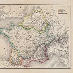
The Empire of Charlemagne (742-814) from Le Nouveau Theatre du Monde
 from Le Nouveau Theatre du Monde")
![]()
Wall Art and Photo Gifts from Fine Art Finder
The Empire of Charlemagne (742-814) from Le Nouveau Theatre du Monde
CHT165851 The Empire of Charlemagne (742-814) from Le Nouveau Theatre du Monde, 1639 (coloured engraving) by Hondius, Hendrik I (1573-p.1649); Archives du Ministere des Affaires Etrangeres, Paris, France; eArchives Charmet; Dutch, out of copyright
Media ID 23366336
© Archives Charmet / Bridgeman Images
C09th Carolingian Carolus Magnus Cartographical Cartography Charles Continent Henri Henry Holy Roman Empire Karl
FEATURES IN THESE COLLECTIONS
> Animals
> Mammals
> Muridae
> Magnus
> Arts
> Artists
> H
> Hendrik I Hondius
> Europe
> France
> Paris
> Maps
> Europe
> Italy
> Liguria
> Imperia
> Fine Art Finder
> Artists
> Duff Tollemache
> Fine Art Finder
> Artists
> Hendrik I Hondius
> Fine Art Finder
> Maps (celestial & Terrestrial)
EDITORS COMMENTS
This print showcases "The Empire of Charlemagne (742-814)" from Le Nouveau Theatre du Monde, a renowned piece of cartography created in 1639 by Hendrik I Hondius. The coloured engraving beautifully depicts the vast and influential empire ruled by Charlemagne, also known as Carolus Magnus or Charles the Great. Charlemagne's empire, often referred to as the Holy Roman Empire, was a dominant force during the 9th century. This map provides an intricate view of Europe during that period, highlighting the territories under his rule and illustrating his significant impact on continental politics. The attention to detail in this cartographical masterpiece is truly remarkable. Every line and contour meticulously portrays borders, cities, rivers, and mountains across the expansive realm. It offers viewers a glimpse into a world shaped by Charlemagne's vision for unity and prosperity. As we admire this historical artifact captured through Bridgeman Images' lens, we are transported back in time to an era when emperors held immense power over vast domains. The engraving serves as both a testament to Charlemagne's legacy and an ode to the artistry involved in creating such intricate maps. With its vibrant colors and precise craftsmanship, this print allows us to appreciate not only the historical significance but also the artistic beauty inherent in ancient cartography. It reminds us that even centuries later, these visual representations continue to captivate our imagination with their ability to transport us into different worlds.
MADE IN THE UK
Safe Shipping with 30 Day Money Back Guarantee
FREE PERSONALISATION*
We are proud to offer a range of customisation features including Personalised Captions, Color Filters and Picture Zoom Tools
SECURE PAYMENTS
We happily accept a wide range of payment options so you can pay for the things you need in the way that is most convenient for you
* Options may vary by product and licensing agreement. Zoomed Pictures can be adjusted in the Basket.