Home > Europe > Netherlands > Maps
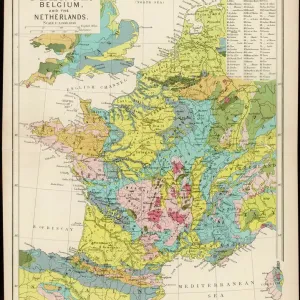
Discovery of the New World (Discovery of America): Dutch map of the New Netherlands and New England, colonies of the Netherlands and Great Britain, circa 1630. 19th century color engraving reproduction of a map of Delaet
: Dutch map of the New Netherlands and New England, colonies of the Netherlands and Great Britain, circa 1630. 19th century color engraving reproduction of a map of Delaet")
![]()
Wall Art and Photo Gifts from Fine Art Finder
Discovery of the New World (Discovery of America): Dutch map of the New Netherlands and New England, colonies of the Netherlands and Great Britain, circa 1630. 19th century color engraving reproduction of a map of Delaet
NWI4848829 Discovery of the New World (Discovery of America): Dutch map of the New Netherlands and New England, colonies of the Netherlands and Great Britain, circa 1630. 19th century color engraving reproduction of a map of Delaet; (add.info.: Discovery of the New World (Discovery of America): Dutch map of the New Netherlands and New England, colonies of the Netherlands and Great Britain, circa 1630. 19th century color engraving reproduction of a map of Delaet); Photo © North Wind Pictures
Media ID 38166122
© Photo © North Wind Pictures / Bridgeman Images
Discovered From America Geographical Map Northwind
FEATURES IN THESE COLLECTIONS
> Europe
> Netherlands
> Maps
> Europe
> Netherlands
> Posters
> Europe
> Netherlands
> Related Images
> Europe
> United Kingdom
> England
> Maps
> Fine Art Finder
> Artists
> Charles Robert Knight
> Maps and Charts
> Netherlands
> Maps and Charts
> World
> North America
> United States of America
> Maps
EDITORS COMMENTS
This 19th-century color engraving reproduction of a Dutch map from circa 1630 showcases the Discovery of the New World, specifically the New Netherlands and New England colonies established by both the Netherlands and Great Britain. The intricate details on this map provide a glimpse into the colonial ambitions and geographical knowledge of that era.
The map, originally created by Delaet, offers a fascinating look at how these European powers viewed and divided up the newly discovered lands in North America. It serves as a reminder of the complex history of colonialism and exploration that shaped the world we live in today.
As we study this historical artifact, we are transported back to a time when new frontiers were being explored and boundaries were being redrawn. The colors and intricacies of this engraving bring to life an important chapter in human history, highlighting both the achievements and consequences of these early voyages of discovery.
Through this print, we can appreciate not only the artistry involved in cartography but also reflect on how our understanding of geography has evolved over time. It is a testament to human curiosity and ambition that continues to drive us forward into new realms of exploration and knowledge.
MADE IN THE UK
Safe Shipping with 30 Day Money Back Guarantee
FREE PERSONALISATION*
We are proud to offer a range of customisation features including Personalised Captions, Color Filters and Picture Zoom Tools
SECURE PAYMENTS
We happily accept a wide range of payment options so you can pay for the things you need in the way that is most convenient for you
* Options may vary by product and licensing agreement. Zoomed Pictures can be adjusted in the Basket.