Home > North America > United States of America > New York > New York > Maps
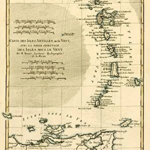
North-East Coast of America, from Atlas de Toutes les Parties Connues du Globe

![]()
Wall Art and Photo Gifts from Fine Art Finder
North-East Coast of America, from Atlas de Toutes les Parties Connues du Globe
KW205892 North-East Coast of America, from Atlas de Toutes les Parties Connues du Globe Terrestre by Guillaume Raynal (1713-96), published J L Pellet, Geneva, 1780 (coloured engraving) by Bonne, Charles Marie Rigobert (1727-95); Private Collection; Ken Welsh; French, out of copyright
Media ID 12755475
© www.bridgemanimages.com
Boston Erie Long Island Massachusetts New England New Jersey Pennsylvania Lake Ontario
FEATURES IN THESE COLLECTIONS
> Arts
> Artists
> B
> Charles Marie Rigobert Bonne
> Europe
> United Kingdom
> England
> Lakes
> Europe
> United Kingdom
> England
> Maps
> Europe
> United Kingdom
> England
> York
> Fine Art Finder
> Artists
> Charles Marie Rigobert Bonne
> Fine Art Finder
> Maps (celestial & Terrestrial)
> North America
> United States of America
> Lakes
> Lake Ontario
> North America
> United States of America
> Maps
> North America
> United States of America
> Massachusetts
> Boston
> North America
> United States of America
> New Jersey
> Related Images
> North America
> United States of America
> New York
> New York
> Maps
EDITORS COMMENTS
This print takes us back in time to the North-East Coast of America as depicted in an ancient atlas. The image, a coloured engraving from the 18th century, showcases the remarkable work of Guillaume Raynal and Charles Marie Rigobert Bonne. Published in Geneva in 1780, this piece offers a glimpse into the historical geography of America during that era. The map encompasses various states including New England, Pennsylvania, New Jersey, Massachusetts, and New York. It highlights prominent cities such as Boston and Long Island while also featuring significant bodies of water like Lake Ontario and Lake Erie. This detailed representation provides invaluable insight into how these regions were perceived centuries ago. As we observe this fascinating artwork from a private collection curated by Ken Welsh, it is important to appreciate its historical significance. The intricate details captured within each stroke reflect the meticulous craftsmanship employed by Bonne to bring this map to life. Through this photo print, we are transported back in time; our imagination wanders along the coastlines and explores bustling towns that have evolved over generations. It serves as a reminder of how far we have come while honoring those who paved the way for modern cartography.
MADE IN THE UK
Safe Shipping with 30 Day Money Back Guarantee
FREE PERSONALISATION*
We are proud to offer a range of customisation features including Personalised Captions, Color Filters and Picture Zoom Tools
SECURE PAYMENTS
We happily accept a wide range of payment options so you can pay for the things you need in the way that is most convenient for you
* Options may vary by product and licensing agreement. Zoomed Pictures can be adjusted in the Basket.