Home > Arts > Artists > B > Charles Marie Rigobert Bonne
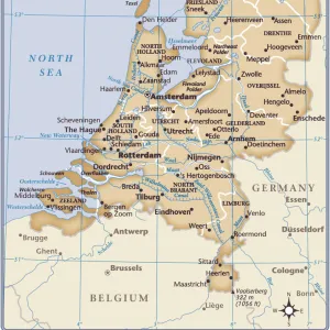
Holland Including the Seven United Provinces of the Low Countries, from Atlas

![]()
Wall Art and Photo Gifts from Fine Art Finder
Holland Including the Seven United Provinces of the Low Countries, from Atlas
KW206605 Holland Including the Seven United Provinces of the Low Countries, from Atlas de Toutes les Parties Connues du Globe Terrestre by Guillaume Raynal (1713-96) published 1780 (coloured engraving) by Bonne, Charles Marie Rigobert (1727-95); Private Collection; Ken Welsh; French, out of copyright
Media ID 12755745
© www.bridgemanimages.com
FEATURES IN THESE COLLECTIONS
> Arts
> Artists
> B
> Charles Marie Rigobert Bonne
> Europe
> Netherlands
> Amsterdam
> Europe
> Netherlands
> Maps
> Fine Art Finder
> Artists
> Charles Marie Rigobert Bonne
> Fine Art Finder
> Maps (celestial & Terrestrial)
> Maps and Charts
> Netherlands
EDITORS COMMENTS
This print showcases the historical map titled "Holland Including the Seven United Provinces of the Low Countries". Created by Guillaume Raynal and published in 1780, this beautifully colored engraving offers a glimpse into the rich cartographic heritage of the Netherlands. The intricate details and precision of this map are truly remarkable. The image takes us back to a time when Holland was known for its flourishing trade, vibrant cities, and innovative spirit. It depicts Amsterdam, one of Europe's most influential centers during that era. The Dutch capital is showcased with meticulous accuracy, highlighting its iconic canals, bustling streets, and impressive architecture. As we explore this print further, we discover that it belongs to a private collection cared for by Ken Welsh. Its inclusion in Atlas de Toutes les Parties Connues du Globe Terrestre emphasizes its significance as an important piece of historical documentation. The colors used in this engraving bring life to every corner of the map – from lush green landscapes to winding waterways – inviting us to immerse ourselves in Holland's past glory. This artwork serves as a reminder of how maps have not only guided travelers but also shaped our understanding of different regions throughout history. With its timeless appeal and cultural significance, this print is sure to captivate admirers who appreciate both artistry and historical exploration.
MADE IN THE UK
Safe Shipping with 30 Day Money Back Guarantee
FREE PERSONALISATION*
We are proud to offer a range of customisation features including Personalised Captions, Color Filters and Picture Zoom Tools
SECURE PAYMENTS
We happily accept a wide range of payment options so you can pay for the things you need in the way that is most convenient for you
* Options may vary by product and licensing agreement. Zoomed Pictures can be adjusted in the Basket.