Home > North America > United States of America > New York > New York > Maps
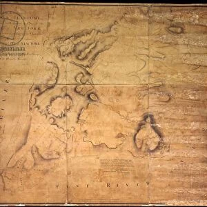
Map of the City of New York, 1850 (black ink, with colour wash, on paper)
")
![]()
Wall Art and Photo Gifts from Fine Art Finder
Map of the City of New York, 1850 (black ink, with colour wash, on paper)
1079218 Map of the City of New York, 1850 (black ink, with colour wash, on paper) by Hayward, George (c.1800-72); 39x49 cm; Collection of the New-York Historical Society, USA; (add.info.: Map of the City of New York, 1850. Maps from D.T. Valentines Manual of the Corporation of the City of New York and his History of New York); eNew York Historical Society; American, out of copyright
Media ID 23029834
© New York Historical Society / Bridgeman Images
Downtown Lower Manhattan Manhattan Surveys
FEATURES IN THESE COLLECTIONS
> Arts
> Artists
> A
> Carolus Allardt
> Arts
> Artists
> H
> George Hayward
> Arts
> Portraits
> Pop art gallery
> Street art portraits
> Fine Art Finder
> Artists
> Carolus Allardt
> Fine Art Finder
> Artists
> George Hayward
> Maps and Charts
> Early Maps
> North America
> United States of America
> Maps
> North America
> United States of America
> New York
> New York
> Manhattan
> Related Images
> North America
> United States of America
> New York
> New York
> Maps
EDITORS COMMENTS
This print showcases a remarkable piece of history - the "Map of the City of New York, 1850" by George Hayward. Created with black ink and enhanced with a delicate color wash on paper, this map measures 39x49 cm and is proudly held in the esteemed collection of the New-York Historical Society in the USA. The map itself provides an intriguing glimpse into mid-19th century New York City. It offers a detailed depiction of downtown Manhattan, showcasing its bustling streets and vibrant neighborhoods. With meticulous surveys conducted by Hayward, this map serves as both a navigational tool and an invaluable historical document. As we explore this image further, it becomes apparent that every street corner holds stories waiting to be discovered. The meticulously drawn buildings and thoroughfares transport us back to an era when horse-drawn carriages roamed these very streets. This particular print captures not only the essence of American urban planning but also reflects America's growth during this transformative period in history. It stands as a testament to George Hayward's dedication to cartography and his contribution to documenting the ever-evolving cityscape. Whether you are an avid historian or simply captivated by maps, this stunning print allows you to immerse yourself in the rich tapestry that is New York City's past.
MADE IN THE UK
Safe Shipping with 30 Day Money Back Guarantee
FREE PERSONALISATION*
We are proud to offer a range of customisation features including Personalised Captions, Color Filters and Picture Zoom Tools
SECURE PAYMENTS
We happily accept a wide range of payment options so you can pay for the things you need in the way that is most convenient for you
* Options may vary by product and licensing agreement. Zoomed Pictures can be adjusted in the Basket.