
Maps Collection
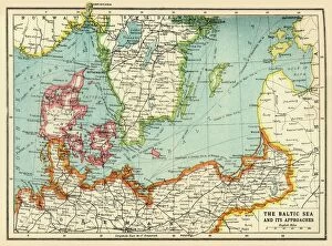
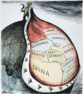
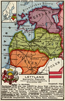
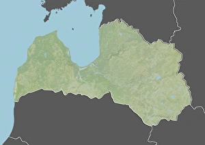
Latvia is a small country located in the Baltic region of Europe, and is bordered by Estonia to the north, Lithuania to the south
Choose a picture from our Maps Collection for your Wall Art and Photo Gifts
41 items


All Professionally Made to Order for Quick Shipping
-
Maps Collection
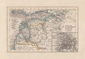
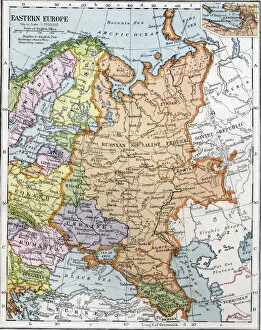
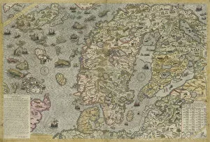
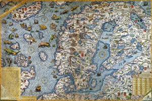
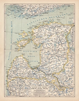
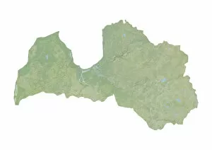
Latvia is a small country located in the Baltic region of Europe, and is bordered by Estonia to the north, Lithuania to the south, Belarus to the east and Russia to the southeast. Latvia has a long and varied history, with its earliest inhabitants dating back over 10,000 years ago. The country has an area of 64 589 km2 and is divided into four regions: Kurzeme (Courland), Vidzeme (Livonia), Latgale (Latgallia) and Zemgale (Semigalia). Maps of Latvia show its diverse terrain which includes forests, rivers, lakes and coastal plains. The capital city Riga is located on the Gulf of Riga at the mouth of Daugava River. Other major cities include Liepaja, Ventspils and Jelgava. Latvia's economy relies heavily on exports such as timber products, foodstuffs and machinery as well as tourism which makes up around 10% of GDP.
+
Our beautiful pictures are available as Framed Prints, Photos, Wall Art and Photo Gifts
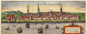
The Maps of Latvia Europe collection from Media Storehouse is a stunning selection of wall art and framed prints that showcase the beauty and history of Latvia. Our collection features an array of maps, ranging from antique maps dating back to the 16th century to modern-day maps highlighting the country's cities, rivers, and landmarks. Each piece in our collection is carefully crafted with high-quality materials, ensuring that every detail is captured with precision. The vibrant colors and intricate details make these pieces perfect for adding a touch of sophistication to any room. Whether you're looking for a unique way to decorate your home or office or searching for a thoughtful gift for someone special, the Maps of Latvia Europe collection has something for everyone. With its rich history and breathtaking landscapes, Latvia is truly one-of-a-kind – and now you can bring its beauty into your own space with these stunning works of art.
+
What are Maps of Latvia Europe art prints?
Maps of Latvia Europe art prints are high-quality reproductions of maps that depict the country of Latvia and its surrounding areas in Europe. These prints showcase the intricate details and features of the region, including cities, rivers, mountains, and other geographical landmarks. These art prints are perfect for anyone who loves history or geography or has a connection to Latvia. They can be used as decorative pieces in homes or offices, adding a touch of sophistication to any space. Additionally, they make great gifts for friends or family members who have an interest in cartography. We offer a wide range of Maps of Latvia Europe art prints that cater to different tastes and preferences. You can choose from various sizes and finishes such as canvas, framed print or poster depending on their needs. With our vast collection available online you can easily browse through options at their leisure before making a purchase decision.
+
What Maps of Latvia Europe art prints can I buy from Media Storehouse?
We offer a wide range of Maps of Latvia Europe art prints that are perfect for those who love to explore the beauty and culture of this Baltic country. These maps showcase the topography, cities, towns, rivers and lakes of Latvia in great detail. You can choose from vintage maps that depict the historical evolution of Latvia's borders or modern-day maps with updated information on infrastructure and transportation networks. Media Storehouse also offers customizable options such as framing, canvas printing or poster printing to suit your personal preferences. Whether you're looking for a unique gift for someone special or want to add some character to your home decor, these Maps of Latvia Europe art prints are sure to impress. With our high-quality printing technology and exceptional customer service, you can be assured that you'll receive a product that meets your expectations.
+
How do I buy Maps of Latvia Europe art prints?
To buy Maps of Latvia Europe art prints from Media Storehouse, you can simply browse our online collection and select the print that catches your eye. Once you have found the perfect map, click on it to view more details about the product. From there, you will be able to choose your preferred size and framing options before adding it to your cart. We offer a wide range of high-quality art prints featuring maps of Latvia and other European countries. Their selection includes vintage maps as well as modern interpretations, so you are sure to find something that suits your taste. When purchasing a map print from Media Storehouse, make sure to double-check all order details before completing your purchase. This will ensure that you receive exactly what you want without any issues or delays in delivery. With our easy-to-use website and extensive collection of maps, buying art prints has never been easier.
+
How much do Maps of Latvia Europe art prints cost?
We offer a wide range of Maps of Latvia Europe art prints at varying prices. Our collection includes high-quality reproductions of antique maps as well as modern interpretations created by talented artists. The cost of each print depends on several factors such as the size, framing options, and materials used in printing. We take pride in offering affordable prices for our customers without compromising on quality. Each print is carefully crafted to ensure that it meets our strict standards for clarity and color accuracy. Whether you're looking to add a unique touch to your home or office decor or searching for a thoughtful gift idea, our Maps of Latvia Europe art prints are an excellent choice. Please note that the final price may vary depending on the specific product selected and any additional customization options chosen during checkout. We encourage you to browse our selection online or contact us directly if you have any questions about pricing or availability.
+
How will my Maps of Latvia Europe art prints be delivered to me?
Your Maps of Latvia Europe art prints will be delivered to you in a safe and secure manner. We take great care in packaging your order to ensure that it arrives at your doorstep undamaged. Our delivery partners are reliable and efficient, ensuring that your package is delivered to you on time. We offer a range of delivery options depending on your location and the size of the print. For smaller prints, we use standard postal services while larger prints may require special courier services for safe transportation. Once your order has been dispatched, we will send you an email with tracking information so that you can keep track of its progress. If there are any issues with delivery or if you have any questions about your order, our customer service team is always available to assist you. Rest assured that when ordering from Media Storehouse, we strive to provide a hassle-free experience from start to finish.