
Maps Collection
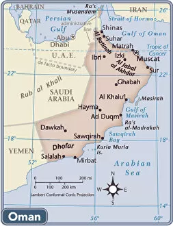
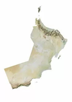
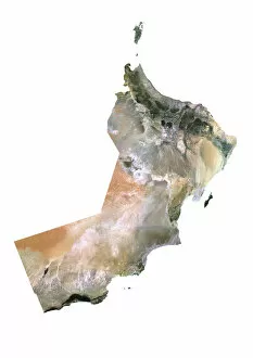
Oman is a country located in the Middle East, on the southeastern coast of the Arabian Peninsula and can bordered by Saudi Arabia to the west
Choose a picture from our Maps Collection for your Wall Art and Photo Gifts
24 items


All Professionally Made to Order for Quick Shipping
-
Maps Collection
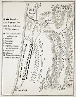
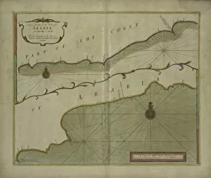
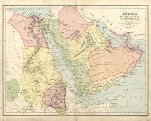
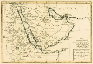
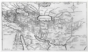
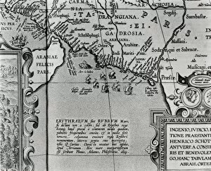
Oman is a country located in the Middle East, on the southeastern coast of the Arabian Peninsula and can bordered by Saudi Arabia to the west, Yemen to the southwest, and United Arab Emirates to the northwest. Maps ofare used for a variety of purposes including travel planning, navigation and exploration. They provide detailed information about roads, cities and other features such as rivers and mountains. They also show political boundaries between countries as well as international borders with neighboring countries like Yemen and Saudi Arabia and are be used for both recreational activities such as hiking or camping trips or more serious business ventures such as trade or investment opportunities in Oman's growing economy. Maps ofare essential tools for anyone looking to explore this fascinating region of the world.
+
Our beautiful pictures are available as Framed Prints, Photos, Wall Art and Photo Gifts
The Maps of Oman Asia collection is a series of wall art and framed prints offered by Media Storehouse. Our collection features a range of maps that showcase the geography, topography, and historical significance of Oman in Asia. These maps are sourced from various archives and collections around the world, ensuring their authenticity and accuracy. The Maps of Oman Asia collection includes both vintage and contemporary maps that depict different aspects of Oman's history, culture, economy, and natural resources. Some maps highlight the country's strategic location on the Arabian Peninsula while others illustrate its diverse landscapes such as mountains, deserts, coastlines, and oases. These high-quality prints are available in different sizes to suit any space or decor style. They make great gifts for anyone interested in cartography or Middle Eastern history. With their intricate details and vibrant colors, these maps offer a unique glimpse into Oman's past and present.
+
What are Maps of Oman Asia art prints?
Maps of Oman Asia art prints are high-quality reproductions of maps that depict the geography and topography of Oman, a country located in Western Asia. These prints showcase the intricate details and features of Oman's landscape, including its mountains, deserts, coastlines, and cities. They are created using advanced printing techniques that ensure accurate color reproduction and sharpness. These art prints are not only visually stunning but also serve as educational tools for those interested in learning more about Oman's history and culture. They can be used to decorate homes or offices with an exotic touch or given as gifts to friends or family members who have a passion for travel or geography. We offer a wide selection of Maps of Oman Asia art prints in various sizes and formats to suit different preferences. Whether you prefer framed prints, canvas wraps or posters, there is something for everyone at Media Storehouse.
+
What Maps of Oman Asia art prints can I buy from Media Storehouse?
We offer a wide range of Maps of Oman Asia art prints that are perfect for anyone who loves to explore the world or has an interest in geography. These maps showcase the beautiful country of Oman, located in Western Asia, and its surrounding regions. You can choose from various styles and designs, including vintage maps, satellite imagery, topographical maps and more. Whether you're looking for a map to hang on your wall at home or office or want to gift it to someone who appreciates unique artwork, we have got you covered. The Maps of Oman Asia art prints come in different sizes and formats such as canvas prints, framed prints or poster prints so that you can select one according to your preference. These stunning artworks will not only add beauty but also provide valuable information about the region's geography and landmarks. So why wait? Browse through our collection today and find the perfect map print that suits your style.
+
How do I buy Maps of Oman Asia art prints?
To buy Maps of Oman Asia art prints from Media Storehouse, you can browse our extensive collection online. Simply search for "Maps of Oman" or "Asia art prints" on our website and select the print that catches your eye. Once you have found a print that you like, add it to your cart and proceed to checkout. During the checkout process, you will be prompted to enter your shipping information and payment details. After completing these steps, your order will be processed and shipped out to you in a timely manner. We offer high-quality prints that are perfect for adding some unique flair to any room in your home or office. Whether you're looking for a map of Oman or an artistic representation of Asia, they have something for everyone. So why wait? Start browsing today and find the perfect piece to complement your decor.
+
How much do Maps of Oman Asia art prints cost?
We offer a wide range of Maps of Oman Asia art prints at varying prices. Our selection includes high-quality reproductions of antique maps and contemporary designs that capture the beauty and diversity of this fascinating region. The cost of our Maps of Oman Asia art prints depends on several factors such as size, framing options, and printing materials. We strive to provide affordable options for all budgets while maintaining the highest standards in quality and craftsmanship. Whether you're looking for a unique piece to decorate your home or office or searching for a thoughtful gift for someone special, our collection has something to suit every taste and style. Browse our website today to discover the perfect Maps of Oman Asia art print that speaks to you.
+
How will my Maps of Oman Asia art prints be delivered to me?
Your Maps of Oman Asia art prints will be delivered to you via standard mail or courier service, depending on your location and the size of the print. We take great care in packaging our products to ensure they arrive at their destination in perfect condition. Your print will be carefully rolled up and placed inside a sturdy cardboard tube for protection during transit. Once your order has been processed and shipped, you will receive an email notification with tracking information so that you can monitor its progress. Delivery times may vary depending on your location, but we strive to deliver all orders as quickly as possible. We are committed to providing our customers with high-quality products and excellent customer service. If you have any questions or concerns about your order, please do not hesitate to contact us and we will do everything we can to assist you.