
Nicolas de Fer Collection
Nicolas de Fer (1646-1720) was a French cartographer and publisher who produced some of the most beautiful maps of his time
Choose a picture from our Nicolas de Fer Collection for your Wall Art and Photo Gifts
25 items


All Professionally Made to Order for Quick Shipping
-
Nicolas de Fer Collection
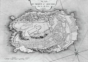
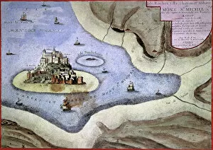
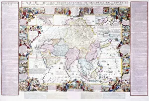
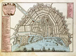
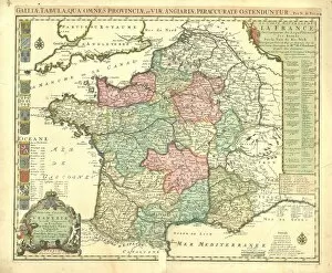
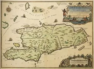
Nicolas de Fer (1646-1720) was a French cartographer and publisher who produced some of the most beautiful maps of his time. He was born in Paris and studied at the Collège des Quatre Nations. He established his own printing business in 1690, which became one of the most important map-making companies in Europe. De Fer's works were renowned for their accuracy, detail, and beauty; he often included decorative features such as ships, sea monsters, and allegorical figures on his maps. His works were widely copied by other publishers throughout Europe and even into North America. De Fer's influence on cartography is still felt today; many modern maps are based on his work or inspired by it.
+
Our beautiful pictures are available as Framed Prints, Photos, Wall Art and Photo Gifts
The Nicolas de Fer collection, available on Media Storehouse, offers a wide range of wall art options including framed prints, photo prints, canvas prints, jigsaw puzzles and greeting cards. Our collection features the works of Nicolas de Fer who was a French cartographer and geographer in the late 17th century. His maps were highly detailed and accurate for their time period and are still admired today for their beauty and historical significance. Our collection includes various maps depicting different regions around the world such as Europe, Asia, Africa and America. Each map is intricately designed with vibrant colors that make them visually appealing while also providing valuable information about the geography of each region. Whether you're looking to add some historical charm to your home or office space or simply appreciate the beauty of antique maps, the Nicolas de Fer collection has something for everyone. With so many options available in different sizes and formats, it's easy to find a piece that fits your personal style preferences.
+
What are Nicolas de Fer (Artists Arts) art prints?
Nicolas de Fer was a French cartographer and engraver who lived in the late 17th century. His work is known for its intricate detail, accuracy, and artistic flair. Nicolas de Fer's art prints are reproductions of his original maps and engravings that depict various regions of Europe, Asia, Africa, and America. These prints showcase his mastery of cartography as well as his unique style that blends scientific precision with decorative elements such as ornate borders and elaborate illustrations. Nicolas de Fer's art prints are perfect for history buffs, collectors, or anyone who appreciates fine art. They make great additions to home decor or office spaces and can serve as educational tools for students studying geography or history. With their high-quality printing techniques on premium paper stock, these art prints capture every detail of Nicolas de Fer's original works while preserving their historical significance for generations to come.
+
What Nicolas de Fer (Artists Arts) art prints can I buy from Media Storehouse?
We offer a wide range of Nicolas de Fer art prints for purchase. The French cartographer and engraver created intricate maps, globes, and celestial charts during the late 17th and early 18th centuries. His works are highly detailed with decorative elements such as sea monsters, ships, and mythological figures. Some popular Nicolas de Fer prints available at Media Storehouse include his world map from 1705 which features ornate borders with depictions of the four seasons and zodiac signs. Another notable print is his celestial chart from 1693 which showcases constellations along with illustrations of Greek gods. In addition to these pieces, Media Storehouse also offers various other Nicolas de Fer maps including regional maps of Europe, Asia, Africa, and America. These art prints make great additions to any home or office decor for those who appreciate historical cartography or simply enjoy beautiful artwork.
+
How do I buy Nicolas de Fer (Artists Arts) art prints?
To purchase Nicolas de Fer art prints from Media Storehouse, you can browse our collection of available pieces on our website or through a third-party retailer. Once you have selected the artwork that you would like to purchase, simply add it to your cart and proceed to checkout. You will be prompted to enter your shipping and billing information, as well as any applicable discount codes or gift cards. We offer a variety of payment options including credit card, PayPal, and Apple Pay. After completing your order, you will receive a confirmation email with details about your purchase. It is important to note that while We offer high-quality reproductions of Nicolas de Fer's work, they are not affiliated with the artist or his estate. As such, these prints should not be considered original works of art but rather affordable alternatives for those who appreciate de Fer's style and subject matter.
+
How much do Nicolas de Fer (Artists Arts) art prints cost?
As a leading online retailer of art prints, we offer a wide range of Nicolas de Fer's artworks at competitive prices. The cost of Nicolas de Fer's art prints varies depending on the size and type of print you choose. Generally, smaller prints are less expensive than larger ones, while canvas or framed prints tend to be more costly than paper ones. Nicolas de Fer was a renowned French cartographer and engraver who produced some of the most beautiful maps and atlases in the 17th century. His works were highly sought after by collectors and connoisseurs alike for their accuracy, detail, and artistic quality. We offer a variety of Nicolas de Fer's art prints that capture his unique style and vision. Whether you're looking for an antique map or an intricate illustration, our collection has something for everyone. So why not browse our selection today to find the perfect piece for your home or office?
+
How will my Nicolas de Fer (Artists Arts) art prints be delivered to me?
We take great care in delivering your Nicolas de Fer art prints to you. We use high-quality packaging materials to ensure that your artwork arrives in pristine condition. Your print will be carefully rolled and placed into a sturdy cardboard tube for safe transport. We work with trusted delivery partners who offer reliable and secure shipping services. Once your order has been dispatched, you will receive an email notification with tracking information so that you can monitor the progress of your delivery. We understand how important it is for our customers to receive their orders promptly, which is why we strive to dispatch all orders as quickly as possible. However, please note that delivery times may vary depending on your location and the shipping method selected at checkout. Rest assured that when you order from Media Storehouse, we will do everything we can to ensure a smooth and hassle-free delivery experience.