Fraud Blocker Skip to main content

Home > Arts > Artists > A > Battista Agnese

Battista Agnese Collection

Battista Agnese was an Italian painter and engraver of the 16th century

Choose a picture from our Battista Agnese Collection for your Wall Art and Photo Gifts

76 items

Background imageBattista Agnese Collection: Italy, from an Atlas of the World in 33 Maps, Venice, 1st September 1553 (ink on vellum)

Italy, from an Atlas of the World in 33 Maps, Venice, 1st September 1553 (ink on vellum)
XOT330948 Italy, from an Atlas of the World in 33 Maps, Venice, 1st September 1553 (ink on vellum) by Agnese, Battista (1514-64); Museo Correr, Venice, Italy; Italian, out of copyright

Background imageBattista Agnese Collection: Europe, 16th century nautical map

Europe, 16th century nautical map
Nautical map of Europe, 1544 copy of Agnese Atlas. Several copies of this atlas were produced between 1536 and 1564, in Venice, by the Italian mapmaker Battista Agnese

Background imageBattista Agnese Collection: Zodiac as spheres with the earth in the center (from the Portolan Atlas), 1546

Zodiac as spheres with the earth in the center (from the Portolan Atlas), 1546. Artist: Agnese, Battista (c. 1500-1564)
Zodiac as spheres with the earth in the center (from the Portolan Atlas), 1546. Found in the collection of the New York Public Library

Background imageBattista Agnese Collection: Atlas compass, 16th century

Atlas compass, 16th century
Atlas compass in a 1544 copy of the Agnese Atlas. Several copies of this atlas were produced between 1536 and 1564, in Venice, by the Italian mapmaker Battista Agnese

Background imageBattista Agnese Collection: Oval planisphere of the world showing Magellan's track, 1554 (vellum)

Oval planisphere of the world showing Magellan's track, 1554 (vellum)
7339654 Oval planisphere of the world showing Magellan's track, 1554 (vellum) by Agnese, Battista (c.1500-64); 26x40 cm; National Maritime Museum, London

Background imageBattista Agnese Collection: Chart of Black Sea, 1554 (vellum)

Chart of Black Sea, 1554 (vellum)
7339645 Chart of Black Sea, 1554 (vellum) by Agnese, Battista (c.1500-64); 26x40 cm; National Maritime Museum, London, UK; (add.info.: Creator: Johan B. Agnese 'Die Tartareioda'. Scale: 1:15 000 000)

Background imageBattista Agnese Collection: Persia, 1554 (vellum)

Persia, 1554 (vellum)
7339640 Persia, 1554 (vellum) by Agnese, Battista (c.1500-64); 26x40 cm; National Maritime Museum, London, UK; (add.info.: Creator: Battista Agnese Bound sheet. Col. ms. Medium: Vellum. Scale: [ca)

Background imageBattista Agnese Collection: Chart of Negroponte, 1554 (vellum)

Chart of Negroponte, 1554 (vellum)
7339644 Chart of Negroponte, 1554 (vellum) by Agnese, Battista (c.1500-64); 26x40 cm; National Maritime Museum, London, UK; (add.info.: Creator: Battista Agnese Scale: 1)

Background imageBattista Agnese Collection: Map of Scandinavia, 1554 (vellum)

Map of Scandinavia, 1554 (vellum)
7339651 Map of Scandinavia, 1554 (vellum) by Agnese, Battista (c.1500-64); 26x40 cm; National Maritime Museum, London, UK; (add.info.: Creator)

Background imageBattista Agnese Collection: Chart of Moscow and the Black Sea, 1554 (vellum)

Chart of Moscow and the Black Sea, 1554 (vellum)
7339650 Chart of Moscow and the Black Sea, 1554 (vellum) by Agnese, Battista (c.1500-64); 26x40 cm; National Maritime Museum, London, UK; (add.info.: Creator: Johan B. Agnese 'Moscaw oder Reuss')

Background imageBattista Agnese Collection: Map of Malta, 1554 (vellum)

Map of Malta, 1554 (vellum)
7339642 Map of Malta, 1554 (vellum) by Agnese, Battista (c.1500-64); 60x40 cm; National Maritime Museum, London, UK; (add.info.: Creator: Battista Agnese); © National Maritime Museum, Greenwich

Background imageBattista Agnese Collection: Chart of Sicily, 1554 (vellum)

Chart of Sicily, 1554 (vellum)
7339643 Chart of Sicily, 1554 (vellum) by Agnese, Battista (c.1500-64); 26x40 cm; National Maritime Museum, London, UK; (add.info.: Creator)

Background imageBattista Agnese Collection: The Sea of Galilee, from an Atlas of the World in 33 Maps, Venice, 1st September 1553

The Sea of Galilee, from an Atlas of the World in 33 Maps, Venice, 1st September 1553
XOT330965 The Sea of Galilee, from an Atlas of the World in 33 Maps, Venice, 1st September 1553 (ink on vellum) (detail from 330966) by Agnese, Battista (1514-64); Museo Correr, Venice

Background imageBattista Agnese Collection: Portolan Atlas

Portolan Atlas
Map of Magellans Route 1544, Agnese, Battista

Background imageBattista Agnese Collection: Planisphere (or world map). Geographic chart from the Atlas of Battista Agnese (1500-1564

Planisphere (or world map). Geographic chart from the Atlas of Battista Agnese (1500-1564
JLJ4646587 Planisphere (or world map). Geographic chart from the Atlas of Battista Agnese (1500-1564), circa 1543. Paris, B.N

Background imageBattista Agnese Collection: Fos. 11v-12r Chart 3: Indian Ocean, Portolan atlas of the world, Venice, c

Fos. 11v-12r Chart 3: Indian Ocean, Portolan atlas of the world, Venice, c
3482942 Fos. 11v-12r Chart 3: Indian Ocean, Portolan atlas of the world, Venice, c.1542-46 (pen & ink and tempera on vellum) by Agnese

Background imageBattista Agnese Collection: Moschoviae Tabula, map of Russia and European cities along the Volga River

Moschoviae Tabula, map of Russia and European cities along the Volga River
AIS5334417 Moschoviae Tabula, map of Russia and European cities along the Volga River, 1525 (colour manuscript) by Agnese, Battista (1514-64); Biblioteca Nazionale Marciana, Venice

Background imageBattista Agnese Collection: A double-page map of the Atlantic Ocean, showing the east coast of North

A double-page map of the Atlantic Ocean, showing the east coast of North
985950 A double-page map of the Atlantic Ocean, showing the east coast of North and South America, 1544 (illuminated manuscript on vellum) by Agnese

Background imageBattista Agnese Collection: Navigation chart showing China, Ceylon and the Philippines and the Tropics of Cancer

Navigation chart showing China, Ceylon and the Philippines and the Tropics of Cancer and Capricorn, c. 1540 (vellum)
3854274 Navigation chart showing China, Ceylon and the Philippines and the Tropics of Cancer and Capricorn, c.1540 (vellum) by Agnese, Battista (1514-64); Photo © Derek Bayes

Background imageBattista Agnese Collection: Scientific board representing zodiacal signs. B. Agnese. 16th century

Scientific board representing zodiacal signs. B. Agnese. 16th century
GIA4816544 Scientific board representing zodiacal signs. B. Agnese. 16th century. by Agnese, Battista (1514-64); Biblioteca Nazionale Marciana, Venice

Background imageBattista Agnese Collection: Map of the Black Sea including part of present-day Romania, Bulgaria, Turkey, Ukraine

Map of the Black Sea including part of present-day Romania, Bulgaria, Turkey, Ukraine, and Russia, c. 1544. Private Collection

Background imageBattista Agnese Collection: Map of the Black Sea, c. 1544. Creator: Agnese, Battista (c. 1500-1564)

Map of the Black Sea, c. 1544. Creator: Agnese, Battista (c. 1500-1564)
Map of the Black Sea including part of present-day Romania, Bulgaria, Turkey, Ukraine, and Russia, c. 1544. Private Collection

Background imageBattista Agnese Collection: Central America, from an Atlas of the World in 33 Maps, Venice, 1st September 1553

Central America, from an Atlas of the World in 33 Maps, Venice, 1st September 1553
XOT330962 Central America, from an Atlas of the World in 33 Maps, Venice, 1st September 1553 (ink on vellum) (detail from 330960) by Agnese, Battista (1514-64); Museo Correr, Venice, Italy; Italian

Background imageBattista Agnese Collection: Map World Geography

Map World Geography
Map of the World by Battista Agnese, 1543-45. (Photo by: Universal History Archive/UIG)

Background imageBattista Agnese Collection: Magellans route, 16th century map

Magellans route, 16th century map
Magellans route around the world, in a 1544 copy of the Agnese Atlas. Magellans route is shown as a dark line. Ferdinand Magellan (c.1480-1521) set sail from Seville, Spain

Background imageBattista Agnese Collection: Piazza Navonas Agnese Right 18th century Etching

Piazza Navonas Agnese Right 18th century Etching
Artokoloro

Background imageBattista Agnese Collection: Map of Magellans Voyage Around the World, c. 1540 (manuscript on vellum)

Map of Magellans Voyage Around the World, c. 1540 (manuscript on vellum)
XCF701484 Map of Magellans Voyage Around the World, c.1540 (manuscript on vellum) by Agnese, Battista (1514-64); Private Collection; (add.info)

Background imageBattista Agnese Collection: View of the Piazza Navona, from the Views of Rome series, c. 1760 (etching)

View of the Piazza Navona, from the Views of Rome series, c. 1760 (etching)
XJF497244 View of the Piazza Navona, from the Views of Rome series, c.1760 (etching) by Piranesi, Giovanni Battista (1720-78); Private Collection; (add.info.: Vedute di Roma)

Background imageBattista Agnese Collection: The Pacific Ocean, from an Atlas of the World in 33 Maps, Venice, 1st September 1553

The Pacific Ocean, from an Atlas of the World in 33 Maps, Venice, 1st September 1553
XOT330960 The Pacific Ocean, from an Atlas of the World in 33 Maps, Venice, 1st September 1553 (ink on vellum) (see also 330962) by Agnese, Battista (1514-64); 29x49 cm; Museo Correr, Venice

Background imageBattista Agnese Collection: Mount Sinai and the Red Sea, from an Atlas of the World in 33 Maps, Venice, 1st September 1553

Mount Sinai and the Red Sea, from an Atlas of the World in 33 Maps, Venice, 1st September 1553
XOT330964 Mount Sinai and the Red Sea, from an Atlas of the World in 33 Maps, Venice, 1st September 1553 (ink on vellum) (detail from 330963) by Agnese, Battista (1514-64); Museo Correr, Venice

Background imageBattista Agnese Collection: The Holy Land, from an Atlas of the World in 33 Maps, Venice, 1st September 1553

The Holy Land, from an Atlas of the World in 33 Maps, Venice, 1st September 1553
XOT330966 The Holy Land, from an Atlas of the World in 33 Maps, Venice, 1st September 1553 (ink on vellum) (see also 330965) by Agnese, Battista (1514-64); 29x49 cm; Museo Correr, Venice

Background imageBattista Agnese Collection: India and Malaysia, from an Atlas of the World in 33 Maps, Venice, 1st September 1553

India and Malaysia, from an Atlas of the World in 33 Maps, Venice, 1st September 1553
XOT330958 India and Malaysia, from an Atlas of the World in 33 Maps, Venice, 1st September 1553 (ink on vellum) (detail from 330955) by Agnese, Battista (1514-64); Museo Correr, Venice

Background imageBattista Agnese Collection: The Indian Ocean, from an Atlas of the World in 33 Maps, Venice, 1st September 1553

The Indian Ocean, from an Atlas of the World in 33 Maps, Venice, 1st September 1553
XOT330955 The Indian Ocean, from an Atlas of the World in 33 Maps, Venice, 1st September 1553 (ink on vellum) (see also 330956) by Agnese, Battista (1514-64); 29x49 cm; Museo Correr, Venice

Background imageBattista Agnese Collection: The New World, from an Atlas of the World in 33 Maps, Venice, 1st September 1553

The New World, from an Atlas of the World in 33 Maps, Venice, 1st September 1553
XOT330959 The New World, from an Atlas of the World in 33 Maps, Venice, 1st September 1553 (ink on vellum) (see also 330961) by Agnese, Battista (1514-64); 29x49 cm; Museo Correr, Venice

Background imageBattista Agnese Collection: The Middle East, from an Atlas of the World in 33 Maps, Venice, 1st September 1553

The Middle East, from an Atlas of the World in 33 Maps, Venice, 1st September 1553
XOT330963 The Middle East, from an Atlas of the World in 33 Maps, Venice, 1st September 1553 (ink on vellum) (see also 330964) by Agnese, Battista (1514-64); 29x49 cm; Museo Correr, Venice

Background imageBattista Agnese Collection: South America, from an Atlas of the World in 33 Maps, Venice, 1st September 1553

South America, from an Atlas of the World in 33 Maps, Venice, 1st September 1553
XOT330961 South America, from an Atlas of the World in 33 Maps, Venice, 1st September 1553 (ink on vellum) (detail from 330959) by Agnese, Battista (1514-64); Museo Correr, Venice, Italy; Italian

Background imageBattista Agnese Collection: Madagascar, from an Atlas of the World in 33 Maps, Venice, 1st September 1553 (ink on vellum)

Madagascar, from an Atlas of the World in 33 Maps, Venice, 1st September 1553 (ink on vellum)
XOT330957 Madagascar, from an Atlas of the World in 33 Maps, Venice, 1st September 1553 (ink on vellum) (detail from 330955) by Agnese, Battista (1514-64); Museo Correr, Venice, Italy; Italian

Background imageBattista Agnese Collection: Detail from Europe and Central Asia, from an Atlas of the World in 33 Maps, Venice

Detail from Europe and Central Asia, from an Atlas of the World in 33 Maps, Venice
XOT330954 Detail from Europe and Central Asia, from an Atlas of the World in 33 Maps, Venice, 1st September 1553 (ink on vellum) (see also 330953) by Agnese, Battista (1514-64); Museo Correr, Venice

Background imageBattista Agnese Collection: Northern Europe, from an Atlas of the World in 33 maps, Venice, 1st September 1553

Northern Europe, from an Atlas of the World in 33 maps, Venice, 1st September 1553
XOT330951 Northern Europe, from an Atlas of the World in 33 maps, Venice, 1st September 1553 (ink on vellum) (see also 330952) by Agnese, Battista (1514-64); 29x49 cm; Museo Correr, Venice

Background imageBattista Agnese Collection: Part of Africa, from an Atlas of the World in 33 Maps, Venice, 1st September 1553

Part of Africa, from an Atlas of the World in 33 Maps, Venice, 1st September 1553
XOT330956 Part of Africa, from an Atlas of the World in 33 Maps, Venice, 1st September 1553 (ink on vellum) (detail from 330955) by Agnese, Battista (1514-64); Museo Correr, Venice, Italy; Italian

Background imageBattista Agnese Collection: Europe and Central Asia, from an Atlas of the World in 33 Maps, Venice, 1st September 1553

Europe and Central Asia, from an Atlas of the World in 33 Maps, Venice, 1st September 1553
XOT330953 Europe and Central Asia, from an Atlas of the World in 33 Maps, Venice, 1st September 1553 (ink on vellum) (see also 330954) by Agnese, Battista (1514-64); 29x49 cm; Museo Correr, Venice

Background imageBattista Agnese Collection: The Continent of Europe, from an Atlas of the World in 33 Maps, Venice, 1st September 1553

The Continent of Europe, from an Atlas of the World in 33 Maps, Venice, 1st September 1553
XOT330949 The Continent of Europe, from an Atlas of the World in 33 Maps, Venice, 1st September 1553 (ink on vellum) (see also 330950) by Agnese, Battista (1514-64); 29x49 cm; Museo Correr, Venice

Background imageBattista Agnese Collection: Iceland, from an Atlas of the World in 33 maps, Venice, 1st September 1553 (ink on vellum)

Iceland, from an Atlas of the World in 33 maps, Venice, 1st September 1553 (ink on vellum)
XOT330952 Iceland, from an Atlas of the World in 33 maps, Venice, 1st September 1553 (ink on vellum) (detail from 330951) by Agnese, Battista (1514-64); Museo Correr, Venice, Italy; Italian

Background imageBattista Agnese Collection: The Kingdoms of England and Scotland, from an Atlas of the World in 33 Maps, Venice

The Kingdoms of England and Scotland, from an Atlas of the World in 33 Maps, Venice
XOT330950 The Kingdoms of England and Scotland, from an Atlas of the World in 33 Maps, Venice, 1st September 1553 (ink on vellum) (detail from 330949) by Agnese, Battista (1514-64); Museo Correr

Background imageBattista Agnese Collection: Ethiopia, the Red Sea and Saudi Arabia, from an Atlas of the World in 33 Maps, Venice

Ethiopia, the Red Sea and Saudi Arabia, from an Atlas of the World in 33 Maps, Venice
XOT330947 Ethiopia, the Red Sea and Saudi Arabia, from an Atlas of the World in 33 Maps, Venice, 1st September 1553 (ink on vellum) (detail from 330946) by Agnese, Battista (1514-64); Museo Correr

Background imageBattista Agnese Collection: The Continent of Africa, from an Atlas of the World in 33 Maps, Venice, 1st September 1553

The Continent of Africa, from an Atlas of the World in 33 Maps, Venice, 1st September 1553
XOT330946 The Continent of Africa, from an Atlas of the World in 33 Maps, Venice, 1st September 1553 (ink on vellum) (see also 330947) by Agnese, Battista (1514-64); Museo Correr, Venice

Background imageBattista Agnese Collection: Zodiac Calendar, from an Atlas of the World in 33 Maps, Venice, 1st September 1553

Zodiac Calendar, from an Atlas of the World in 33 Maps, Venice, 1st September 1553
XOT330945 Zodiac Calendar, from an Atlas of the World in 33 Maps, Venice, 1st September 1553 (ink on vellum) by Agnese, Battista (1514-64); Museo Correr, Venice, Italy; Italian, out of copyright

Background imageBattista Agnese Collection: World map tracing Magellans world voyage, from the Portolan Atlas of the World, c

World map tracing Magellans world voyage, from the Portolan Atlas of the World, c
XIR280126 World map tracing Magellans world voyage, from the Portolan Atlas of the World, c.1540 (see also 63417, 151822) (engraving) (b/w photo) by Agnese


All Professionally Made to Order for Quick Shipping


-

Battista Agnese Collection

Battista Agnese was an Italian painter and engraver of the 16th century. He was born in Cremona, Italy, and is best known for his religious works. He studied under Francesco Marmitta da Cremona, a local painter. His style was influenced by the Mannerist movement of the time and he often used bright colors to create dramatic scenes. He painted many altarpieces for churches in Lombardy and Piedmont as well as portraits of prominent figures from the region. His engravings include a series depicting scenes from the life of Christ which were widely circulated throughout Europe during his lifetime. Agnese's work has been praised for its technical skill and emotional intensity, making him one of the most important Italian Mannerists of his time.
+

Our beautiful pictures are available as Framed Prints, Photos, Wall Art and Photo Gifts

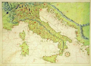
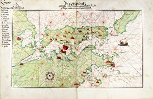
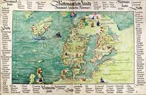
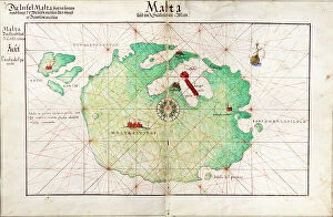
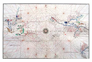
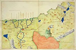
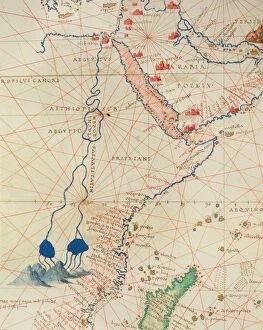
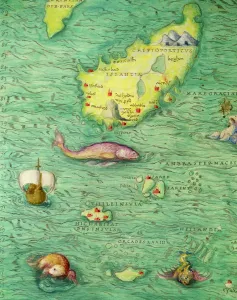
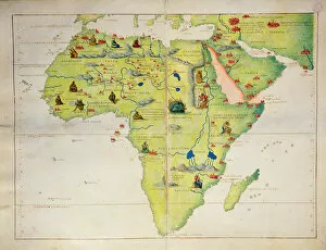
The Battista Agnese collection, available on Media Storehouse, is a stunning selection of wall art, framed prints, photo prints, canvas prints, jigsaw puzzles and greeting cards. Our collection features the works of Battista Agnese - an Italian cartographer who lived in the 16th century. His maps are known for their intricate details and beautiful illustrations that capture the essence of each region they depict. Our collection includes maps from all over Europe including Italy, France and Spain as well as other parts of the world such as Africa and Asia. Each piece is carefully crafted with precision to ensure that every detail is captured perfectly. Whether you're looking to add some historical charm to your home or office space or simply want to appreciate the beauty of these ancient maps; our collection has something for everyone. With a range of sizes and formats available at affordable prices; it's easy to find something that suits your style and budget.
+

What are Battista Agnese (Artists Arts) art prints?

Battista Agnese was a renowned cartographer and artist from the 16th century. His works are highly regarded for their intricate details and accuracy in depicting maps, sea charts, and other nautical illustrations. Today, his art prints are still widely sought after by collectors and enthusiasts alike. We offer a range of Battista Agnese art prints that showcase his exceptional talent as an artist. These prints feature vivid colors and fine details that capture the essence of his work. Whether you're looking to add some historical flair to your home or office decor or simply appreciate the beauty of vintage cartography, our selection of Battista Agnese art prints is sure to impress. From world maps to regional charts, each print is carefully crafted using high-quality materials to ensure its longevity and visual appeal. So why not explore our collection today and discover the timeless beauty of Battista Agnese's artwork?
+

What Battista Agnese (Artists Arts) art prints can I buy from Media Storehouse?

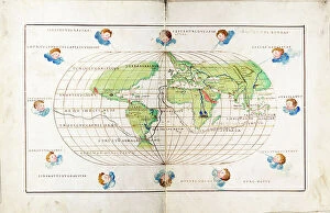
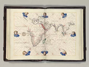
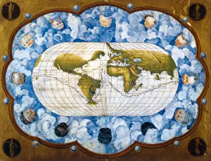
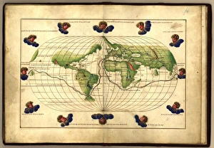
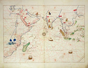
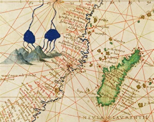
We offer a wide range of Battista Agnese art prints that are available for purchase. These prints showcase the artist's incredible talent and attention to detail, capturing intricate maps and nautical charts from the 16th century. You can choose from a variety of sizes and formats, including canvas prints, framed prints, and posters. Some of the most popular Battista Agnese art prints available at Media Storehouse include his famous world map created in 1544, which features detailed illustrations of sea monsters and mythical creatures. Other notable works include his maps of Italy, Spain, Portugal, Greece, and Turkey. Whether you're looking to add some historical flair to your home or office decor or simply appreciate the beauty of antique cartography artwork, we have something for everyone. With high-quality printing techniques used on premium materials such as fine art paper or canvas fabric ensures that each print is an accurate representation of the original artwork.
+

How do I buy Battista Agnese (Artists Arts) art prints?

To purchase Battista Agnese art prints from Media Storehouse, you can browse our extensive collection of artwork online. Once you have found the print that you would like to purchase, simply add it to your cart and proceed to checkout. During the checkout process, you will be prompted to enter your shipping and billing information. We offer a variety of payment options including credit card and PayPal. Once your order has been processed, your print will be carefully packaged and shipped directly to your door. Battista Agnese was an Italian cartographer who created some of the most beautiful maps in history during the 16th century. His work is highly sought after by collectors and enthusiasts alike for its intricate detail and stunning beauty. By purchasing a Battista Agnese art print from Media Storehouse, you are not only acquiring a piece of history but also supporting artists' arts as well as adding a unique touch to any room in your home or office.
+

How much do Battista Agnese (Artists Arts) art prints cost?

We offer a wide range of Battista Agnese art prints for purchase. The cost of these prints varies depending on the size and type of print that you choose. Our selection includes both framed and unframed options, as well as canvas and paper prints. Battista Agnese was a renowned artist during the Renaissance period, known for his intricate maps and nautical charts. His work is highly sought after by collectors and enthusiasts alike, making our collection of his art prints a valuable addition to any home or office. We take pride in offering high-quality reproductions of Battista Agnese's artwork at competitive prices. Whether you're looking to add some historical flair to your decor or simply appreciate the beauty of his work, we have something for everyone. Browse our selection today to find the perfect piece for your space.
+

How will my Battista Agnese (Artists Arts) art prints be delivered to me?

We take great care in delivering your Battista Agnese art prints to you. We use high-quality packaging materials and ensure that your artwork is protected during transit. Depending on the size of your order, we may ship it using a courier or postal service. All our art prints are carefully rolled and packaged in sturdy tubes to prevent any damage during transportation. Once your order has been dispatched, you will receive an email notification with tracking information so you can easily monitor its progress. We understand how important it is for our customers to receive their orders promptly and in perfect condition. That's why we work hard to ensure that all deliveries are made as quickly and efficiently as possible. Whether you're purchasing one print or several, rest assured that we'll do everything we can to make sure they arrive at your doorstep safe and sound.