Home > Arts > Art Movements > Baroque
Chorographical map of Tuscany from Lucca to Campiglia and the immediate hinterlands, drawing (12683), by Leonardo da Vinci, housed in the Royal Library of Windsor
, by Leonardo da Vinci, housed in the Royal Library of Windsor")
![]()
Wall Art and Photo Gifts from Fondazione Alinari per la Fotografia
Chorographical map of Tuscany from Lucca to Campiglia and the immediate hinterlands, drawing (12683), by Leonardo da Vinci, housed in the Royal Library of Windsor
Chorographical map of Tuscany from Lucca to Campiglia and the immediate hinterlands, drawing (12683), by Leonardo da Vinci, housed in the Royal Library of Windsor Drawing High Renaissance, Renaissance, Renaissance-Baroque styles and periods, Europe, First and Second Millennium A.D.. Date of Photograph:2001. Date of Artwork:1478-1518 ca.. Artist:Leonardo da Vinci (1452-1519)
PDP-S-000GEO-0015
Media ID 33187893
© Alinari Archives, Florence
Geographical Or Topographical Map Geography Instrument And Document Maphigh Renaissance Landscape Hillsides
FEATURES IN THESE COLLECTIONS
> Arts
> Art Movements
> Baroque
> Arts
> Art Movements
> Renaissance Art
> Arts
> Artists
> Leonardo da Vinci
> Renaissance art
> Arts
> Artists
> Leonardo da Vinci
> Sketches and drawings by Leonardo da
> Arts
> Artists
> Leonardo da Vinci
> Arts
> Artists
> Leonardo Da Vinci
> Arts
> Artists
> V
> Leonardo da Vinci
> Arts
> Realistic drawings
> Landscape drawings
> Fine art
EDITORS COMMENTS
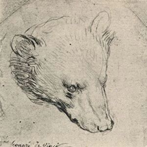
This print captures the intricate beauty of Leonardo da Vinci's "Chorographical map of Tuscany from Lucca to Campiglia and the immediate hinterlands". Housed in the prestigious Royal Library of Windsor, this drawing showcases da Vinci's mastery in multiple artistic styles and periods, including High Renaissance, Renaissance-Baroque, and Renaissance. Created between 1478-1518, this geographical or topographical map is a testament to da Vinci's multifaceted genius. With meticulous attention to detail, he skillfully depicts the landscape of Tuscany with its rolling hillsides and enchanting geography. The artist's profound understanding of cartography shines through as he effortlessly combines artistry with scientific precision. As we delve into this artwork through the lens of Alinari's lens in 2001, we are transported back in time to witness da Vinci's vision firsthand. The composition reveals his deep appreciation for nature and his ability to capture its essence on paper. Every stroke tells a story; every contour breathes life into the land it represents. This masterpiece not only serves as an instrument for navigation but also stands as a historical document that reflects Europe during the First and Second Millennium A. D. It symbolizes an era where knowledge was sought after fervently by scholars like Leonardo da Vinci. Intriguingly blending elements from various artistic movements, this piece encapsulates both innovation and tradition. Its timeless appeal continues to captivate viewers even today—five centuries after its creation—showcasing why Leonardo da Vinci remains one of history’s most revered artists.
MADE IN THE UK
Safe Shipping with 30 Day Money Back Guarantee
FREE PERSONALISATION*
We are proud to offer a range of customisation features including Personalised Captions, Color Filters and Picture Zoom Tools
SECURE PAYMENTS
We happily accept a wide range of payment options so you can pay for the things you need in the way that is most convenient for you
* Options may vary by product and licensing agreement. Zoomed Pictures can be adjusted in the Basket.