
Maps Collection
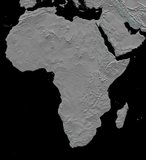
Tanzania is a country located in East Africa, bordered by Kenya and Uganda to the north, Rwanda, Burundi and the Democratic Republic of Congo to the west
Choose a picture from our Maps Collection for your Wall Art and Photo Gifts
21 items


All Professionally Made to Order for Quick Shipping
-
Maps Collection
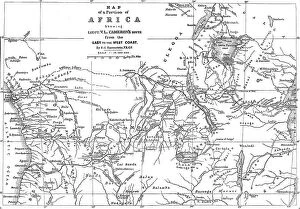
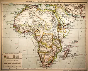
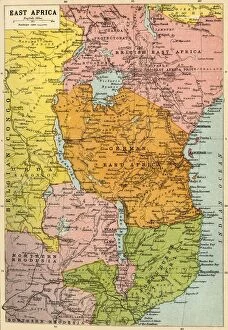
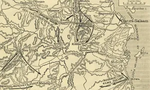
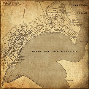
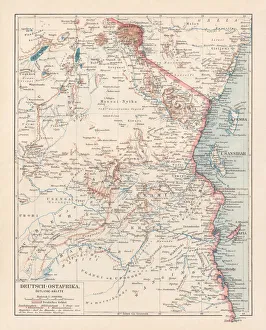
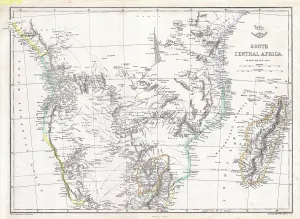
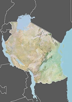
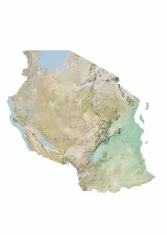
Tanzania is a country located in East Africa, bordered by Kenya and Uganda to the north, Rwanda, Burundi and the Democratic Republic of Congo to the west, Zambia, Malawi and Mozambique to the south and the Indian Ocean to the east. Maps of Tanzania provide an overview of its geography including its major cities such as Dar es Salaam (the capital), Mwanza, Arusha and Dodoma. They also show Tanzania's main rivers such as Rufiji River which flows into Indian Ocean near Dar es Salaam; Lake Victoria which is shared with Kenya and Uganda; Lake Tanganyika which is shared with DR Congo; Lake Nyasa which is shared with Malawi; Kilimanjaro Mountain range; Serengeti National Park in Northern Tanzania famous for its wildlife safaris. It also shows other physical features such as mountains ranges like Usambara Mountains in Eastern part of Tanzania. In addition they show national parks like Gombe Stream National Park where Jane Goodall conducted her chimpanzee research work.
+
Our beautiful pictures are available as Framed Prints, Photos, Wall Art and Photo Gifts
The Maps of Tanzania Africa collection from Media Storehouse offers a stunning array of wall art and framed prints that showcase the beauty and diversity of this East African country. Our collection features a range of maps, including vintage maps dating back to the 19th century, as well as more contemporary designs that highlight Tanzania's natural wonders such as Mount Kilimanjaro and Serengeti National Park. Each print is expertly crafted using high-quality materials to ensure longevity and durability. Our collection is perfect for anyone who loves travel or has an interest in geography, history, or culture. Whether you're looking for a unique piece to add to your home decor or want to give a thoughtful gift to someone special, the Maps of Tanzania Africa collection has something for everyone. This impressive collection captures the essence of Tanzania's rich cultural heritage and natural beauty in stunning detail.
+
What are Maps of Tanzania Africa art prints?
Maps of Tanzania Africa art prints are high-quality reproductions of maps that depict the geography, topography, and political boundaries of Tanzania. These prints are created using state-of-the-art printing technology to ensure that every detail is captured accurately and vividly. They make excellent wall decorations for homes, offices or classrooms. These maps can be used for educational purposes as they provide a visual representation of the country's physical features such as mountains, rivers, lakes and national parks. Additionally, they show important cities and towns in Tanzania along with their respective administrative divisions. Maps of Tanzania Africa art prints come in various sizes and styles to suit different preferences. Some feature antique designs while others have modern aesthetics. They are printed on high-quality paper which ensures durability and longevity. Maps of Tanzania Africa art prints offer an excellent way to showcase your love for geography or African culture while adding a touch of sophistication to any space you choose to display them in.
+
What Maps of Tanzania Africa art prints can I buy from Media Storehouse?
We offer a wide range of Maps of Tanzania Africa art prints that are perfect for anyone who loves African culture and geography. These maps showcase the beautiful country of Tanzania, including its cities, rivers, lakes, mountains and other natural features. You can choose from different styles and designs to suit your taste or decor theme. Some popular options include vintage-style maps that have an antique look and feel with intricate details such as compasses, ships and sea monsters. Other options include modern maps that use bright colours and bold typography to highlight key locations in Tanzania. Whether you're looking for a map print to display in your home or office or as a gift for someone special, we have something for everyone. With high-quality printing technology used on premium paper stock, these Maps of Tanzania Africa art prints will make a stunning addition to any space.
+
How do I buy Maps of Tanzania Africa art prints?
To purchase Maps of Tanzania Africa art prints from Media Storehouse, you can browse our extensive collection online. Simply search for "Maps of Tanzania Africa" in the search bar on our website and select the print that best suits your needs. Once you have found a print that you like, add it to your cart and proceed to checkout. During checkout, you will be prompted to enter your shipping information and payment details. After completing these steps, your order will be processed and shipped directly to your address. We offer a wide range of high-quality art prints featuring maps of Tanzania Africa created by talented artists from around the world. Whether you are looking for a unique piece of wall decor or an educational resource for students or professionals, their selection is sure to meet your needs.
+
How much do Maps of Tanzania Africa art prints cost?
We offer a wide range of Maps of Tanzania Africa art prints at varying prices. The cost of the prints depends on factors such as the size, quality, and type of paper used in printing. We have options for both framed and unframed prints to suit different preferences. Our Maps of Tanzania Africa art prints are carefully curated from a collection of talented artists who specialize in creating beautiful maps that capture the essence and beauty of this African country. These artworks are perfect for anyone looking to add some cultural flair to their home or office space. We take pride in offering high-quality products that meet our customers' needs while also providing excellent value for money. Our team is always available to assist you with any questions or concerns you may have about our products or services.
+
How will my Maps of Tanzania Africa art prints be delivered to me?
We take great care in delivering your Maps of Tanzania Africa art prints to you. Our delivery process is reliable and efficient, ensuring that your artwork arrives at its destination safely and on time. We use trusted shipping partners who specialize in the transportation of delicate items such as art prints. Your Maps of Tanzania Africa art prints will be carefully packaged using high-quality materials to protect them during transit. We offer a range of delivery options to suit your needs, including standard and express delivery services. Once your order has been dispatched, you will receive a tracking number via email so that you can track the progress of your shipment online. If for any reason there are issues with the delivery or if you have any questions about our service, our friendly customer support team is always available to assist you.