
Maps Collection
Maps of Ghana Africa are a great way to explore the country and its many regions
Choose a picture from our Maps Collection for your Wall Art and Photo Gifts
19 items


All Professionally Made to Order for Quick Shipping
-
Maps Collection
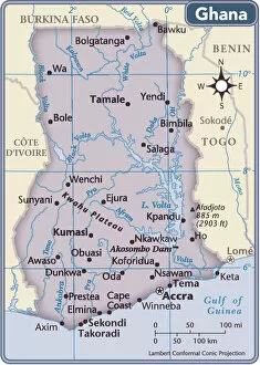
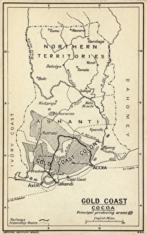
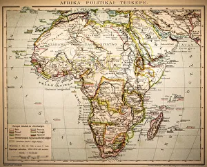
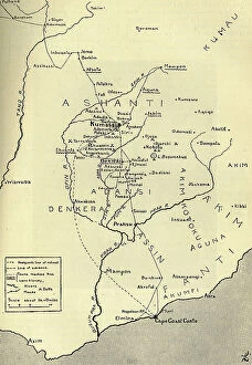
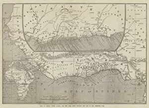
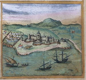
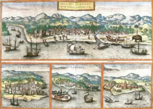
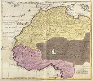
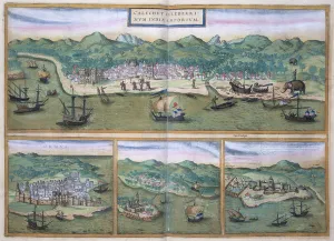
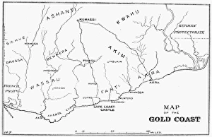
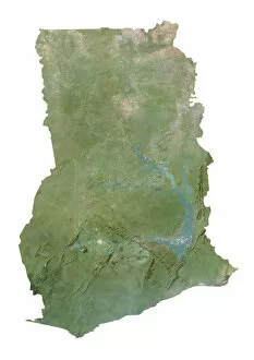
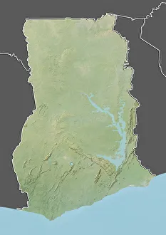
Maps of Ghana Africa are a great way to explore the country and its many regions. Ghana is located in West Africa and is bordered by the Ivory Coast, Burkina Faso, Togo, and the Gulf of Guinea. The country has a population of approximately 28 million people and covers an area of 238,537 square kilometers. Maps of Ghana can show you its major cities such as Accra, Kumasi, Tamale, Sekondi-Takoradi, Sunyani and Cape Coast. They also show you the various rivers that flow through the country such as Volta River which forms part of Lake Volta - one of the largest man-made lakes in the world. It also reveal some interesting facts about Ghana's terrain including its coastal plains along with savannahs and forests in its interior regions. Additionally they can provide information on national parks like Mole National Park which is home to elephants, antelopes and other wildlife species. Finally they are help you plan your trip around this beautiful African nation with ease.
+
Our beautiful pictures are available as Framed Prints, Photos, Wall Art and Photo Gifts
The Maps of Ghana Africa collection from Media Storehouse offers a stunning array of wall art and framed prints that showcase the beauty and diversity of Ghana's landscape. Our collection features an extensive range of maps, including vintage maps dating back to the 19th century as well as contemporary maps that highlight the country's modern infrastructure. Each print is carefully crafted using high-quality materials, ensuring that it will stand the test of time and provide a beautiful addition to any home or office. Whether you're looking for a unique piece to add to your personal collection or want to give a meaningful gift, our collection has something for everyone. From detailed topographical maps that showcase Ghana's rugged terrain to colorful political maps that highlight its diverse regions, our collection captures the essence of one of Africa's most vibrant countries. With so many options available, it's easy to find the perfect map print for your space.
+
What are Maps of Ghana Africa art prints?
Maps of Ghana Africa art prints are artistic representations of the geography and topography of Ghana, a West African country. These prints showcase the various regions, cities, towns, and landmarks that make up the country's landscape. They are created using high-quality printing techniques on premium paper or canvas to ensure they capture every detail accurately. These art prints are not only decorative but also educational as they provide an excellent visual aid for learning about Ghana's geography and history. They can be used in classrooms, offices or homes to add a touch of cultural flair while also serving as a conversation starter. Maps of Ghana Africa art prints come in different sizes and styles to suit individual preferences. Some feature vibrant colors while others have muted tones for a more subtle look. Regardless of your taste, these art prints offer an affordable way to bring a piece of Africa into your space.
+
What Maps of Ghana Africa art prints can I buy from Media Storehouse?
We offer a wide range of Maps of Ghana Africa art prints for purchase. These maps showcase the various regions and cities within Ghana, highlighting their unique features and landmarks. Some popular options include antique-style maps that provide historical context to the country's development, as well as modern-day maps that illustrate its current infrastructure and transportation systems. In addition to traditional paper prints, Media Storehouse also offers canvas prints that add texture and depth to the artwork. You can choose from a variety of sizes to fit their specific needs, whether they want a small print for personal use or a large one for display in a public space. Our selection of Maps of Ghana Africa art prints provides an excellent way to celebrate this vibrant country's rich culture and history. Whether you're looking for something decorative or educational, there is sure to be an option that meets your needs.
+
How do I buy Maps of Ghana Africa art prints?
To buy Maps of Ghana Africa art prints, you can visit our online gallery and browse through their collection. Once you have found the print that you like, simply click on it to view its details and select the size and framing options that suit your preferences. You can then add the print to your cart and proceed to checkout. We offer a wide range of payment options including credit card, PayPal, Apple Pay, Google Pay or Amazon Pay. We also offer worldwide shipping services for their products. When purchasing from Media Storehouse, be sure to read their terms and conditions carefully before making any purchases. This will ensure that you are fully aware of their policies regarding returns or refunds if necessary. Buying Maps of Ghana Africa art prints from Media Storehouse is a simple process that allows you to enjoy beautiful artwork in the comfort of your own home.
+
How much do Maps of Ghana Africa art prints cost?
We offer a wide range of Maps of Ghana Africa art prints at varying prices. Our collection includes vintage maps, modern designs and everything in between. The cost of these prints depends on various factors such as the size, material and design chosen by the customer. We strive to provide high-quality products that are affordable for everyone. Our Maps of Ghana Africa art prints are perfect for those who want to add a touch of African culture to their home or office decor. They make great gifts for anyone interested in geography or history too. With our extensive selection, you're sure to find something that suits your taste and budget. We take pride in offering exceptional customer service and ensuring that our customers receive their orders promptly and securely packaged. If you have any questions about our Maps of Ghana Africa art prints or need assistance with placing an order, please don't hesitate to contact us – we're always happy to help.
+
How will my Maps of Ghana Africa art prints be delivered to me?
We take great care in ensuring that your Maps of Ghana Africa art prints are delivered to you safely and securely. We use high-quality packaging materials to protect your artwork during transit, including sturdy cardboard tubes for rolled prints and flat boxes for framed prints. Our delivery partners are reliable and experienced couriers who will handle your package with the utmost care. You can track your order online using the tracking number provided once it has been dispatched from our warehouse. We offer worldwide shipping options so no matter where you are located, we can deliver your Maps of Ghana Africa art print straight to your doorstep. Our team is dedicated to providing excellent customer service and we strive to ensure that every order is delivered promptly and efficiently. When you receive your artwork, please inspect it carefully to ensure that it has arrived in perfect condition. If there are any issues or concerns, please contact us immediately so we can assist you further.