
Maps Collection
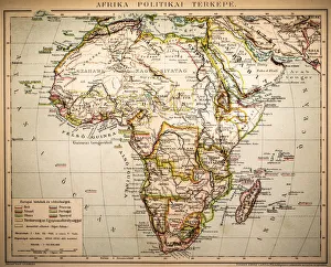
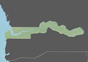
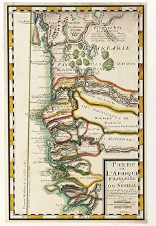
The Gambia is a small West African country located on the Atlantic coast and can bordered by Senegal to the north
Choose a picture from our Maps Collection for your Wall Art and Photo Gifts
19 items


All Professionally Made to Order for Quick Shipping
-
Maps Collection
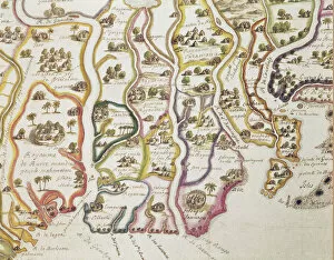
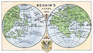
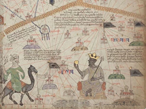
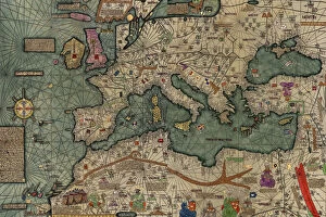
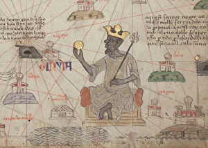
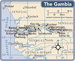
The Gambia is a small West African country located on the Atlantic coast and can bordered by Senegal to the north, east and south and has a population of around 2 million people. Maps show its physical features such as rivers, mountains, forests, lakes and coastal areas. The capital city Banjul is located on St Mary’s Island in the Gambian River estuary. Other major cities include Serekunda, Brikama and Farafenni. The country’s main economic activities are agriculture, fishing and tourism with some mineral resources such as iron ore also present in certain areas. Maps ofalso highlight its national parks which are home to many species of wildlife including elephants, lions, leopards and hippos among others.
+
Our beautiful pictures are available as Framed Prints, Photos, Wall Art and Photo Gifts
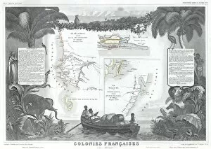
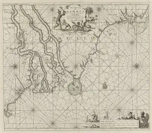
Media Storehouse offers a collection of Maps of The Gambia Africa, which includes wall art and framed prints. Our collection features various maps that depict the geography, topography, and political boundaries of The Gambia. These maps are available in different sizes and formats to suit individual preferences. The Maps of The Gambia Africa collection provides an opportunity for individuals who have an interest in African history or geography to own high-quality prints that showcase the beauty and complexity of this West African country. These maps also serve as educational tools for students studying African geography or history. Media Storehouse ensures that their products are made with high-quality materials to ensure longevity and durability. Their frames are made from sustainable wood sources, while their printing process uses archival-grade ink on acid-free paper to prevent fading over time. The Maps of The Gambia Africa collection is a great addition to any home or office space looking for unique wall decor with historical significance.
+
What are Maps of The Gambia Africa art prints?
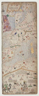
Maps of The Gambia Africa art prints are high-quality reproductions of maps depicting the geography, topography, and political boundaries of The Gambia. These maps are created using advanced printing techniques that ensure accurate reproduction of every detail in the original maps. They are printed on premium quality paper or canvas to provide a long-lasting and durable finish. These art prints serve as an excellent way to showcase your love for African culture and history. They can be used to decorate homes, offices, schools, museums, galleries or any other space where you want to add a touch of elegance and sophistication. Maps of The Gambia Africa art prints come in various sizes and styles to suit different preferences. Some feature vintage designs while others have contemporary styles that appeal to modern tastes. Whether you're looking for a unique gift idea or simply want to enhance your decor with beautiful artwork inspired by African heritage, Maps of The Gambia Africa art prints offer something special for everyone.
+
What Maps of The Gambia Africa art prints can I buy from Media Storehouse?
We offer a wide range of Maps of The Gambia Africa art prints that are available for purchase. These maps showcase the beautiful and diverse landscape of The Gambia, including its rivers, forests, and cities. Some popular options include vintage maps that highlight the country's colonial history as well as more modern depictions that show current political boundaries. In addition to traditional paper prints, Media Storehouse also offers canvas prints and framed options to suit any decor style. You can choose from a variety of sizes to fit their space perfectly. Whether you're looking for a unique piece of wall art or want to add some cultural flair to your home or office, we have something for everyone with their selection of Maps of The Gambia Africa art prints.
+
How do I buy Maps of The Gambia Africa art prints?
To purchase Maps of The Gambia Africa art prints, you can visit our online gallery. We offer a wide selection of high-quality prints that are perfect for adding a touch of African culture to any space. You can browse through our collection and select the print that best suits your taste and preferences. Once you have found the print you want, simply add it to your cart and proceed to checkout. You will be prompted to enter your shipping information and payment details before completing the transaction. We offer secure payment options, so you can rest assured that your personal information is safe during the purchasing process. Once your order has been processed, they will ship it out to you as soon as possible. Buying Maps of The Gambia Africa art prints from Media Storehouse is a simple and convenient process that allows you to bring beautiful African artwork into your home or office with ease.
+
How much do Maps of The Gambia Africa art prints cost?
We offer a wide range of Maps of The Gambia Africa art prints at varying prices. Our collection includes high-quality prints that are perfect for adding a touch of African culture to your home or office space. We have maps in different sizes and styles, ranging from vintage to modern designs. Our Maps of The Gambia Africa art prints are made using premium quality materials to ensure they last for years without fading or losing their vibrancy. They are printed on archival paper with fade-resistant ink, making them suitable for framing and display. The cost of our Maps of The Gambia Africa art prints varies depending on the size and style you choose. However, we strive to provide affordable options that cater to all budgets while maintaining the highest standards of quality. Whether you're looking for a small print or a large statement piece, we have something for everyone at Media Storehouse.
+
How will my Maps of The Gambia Africa art prints be delivered to me?
Your Maps of The Gambia Africa art prints will be delivered to you in a safe and secure manner. We use high-quality packaging materials to ensure that your prints arrive at your doorstep undamaged. Our delivery partners are reliable and efficient, ensuring that your order is delivered on time. We offer various shipping options depending on your location and preferences. You can choose standard or express shipping during checkout, whichever suits you best. We also provide tracking information so that you can keep an eye on the progress of your order. We take pride in our customer service and strive to make sure that every aspect of your purchase is hassle-free. If you have any questions or concerns about the delivery process, please do not hesitate to contact us for assistance.