
Maps Collection
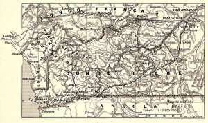
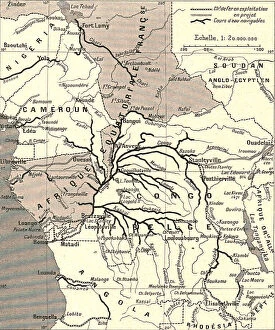
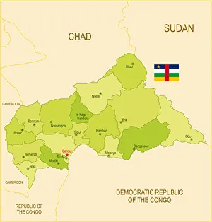
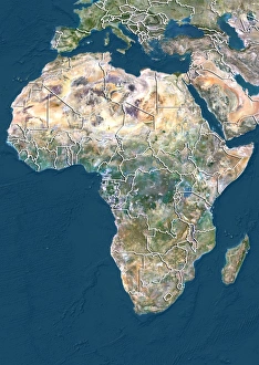
The Central African Republic is a landlocked country located in the heart of Africa, and is bordered by Chad, Sudan, South Sudan
Choose a picture from our Maps Collection for your Wall Art and Photo Gifts
16 items


All Professionally Made to Order for Quick Shipping
-
Maps Collection
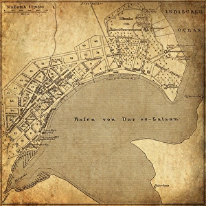
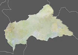
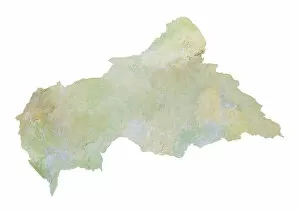
The Central African Republic is a landlocked country located in the heart of Africa, and is bordered by Chad, Sudan, South Sudan, the Democratic Republic of Congo, Cameroon and Gabon. The Central African Republic has an area of about 622,984 square kilometres and a population of approximately 4.7 million people. Maps of the Central African Republic show its diverse terrain which includes savanna grasslands in the north and south and tropical rainforest in the centre. The country also contains several rivers such as Ubangi River which forms part of its western border with Congo-Kinshasa; Sangha River which forms part of its eastern border with Cameroon; Kotto River which flows through Bangui; and Chinko River which flows through southeastern CAR. It also shows that there are several national parks within CAR including Manovo-Gounda St Floris National Park, Dzanga-Ndoki National Park, Bamingui-Bangoran National Park and Zemongo Faunal Reserve.
+
Our beautiful pictures are available as Framed Prints, Photos, Wall Art and Photo Gifts
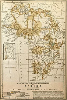
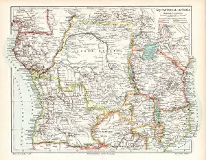
The Maps of Central African Republic Africa collection from Media Storehouse is a stunning compilation of vintage and contemporary maps that showcase the beauty and diversity of this fascinating country. Our collection features a range of maps, including topographical maps, political maps, road maps, and historical maps dating back to the 19th century. Each map has been carefully selected for its unique style and visual appeal. These high-quality prints are perfect for adding a touch of elegance to any home or office space. They are available in various sizes and can be framed or mounted on canvas for an even more impressive display. Whether you're a history buff or simply appreciate beautiful artwork, the Maps of Central African Republic Africa collection is sure to impress. With its rich colors, intricate details, and timeless design, it's no wonder why these prints have become so popular among art enthusiasts around the world.
+
What are Maps of Central African Republic Africa art prints?
Maps of Central African Republic Africa art prints are a unique and visually stunning way to showcase the beauty and diversity of this fascinating country. These prints feature detailed maps of the Central African Republic, highlighting its various regions, cities, and landmarks in intricate detail. They are created using high-quality printing techniques that ensure every line and color is crisp and vibrant. In addition to their practical use as navigational aids, these maps also serve as works of art in their own right. The intricate patterns and designs found on each map make them an eye-catching addition to any home or office decor. Whether you're a history buff looking for an educational piece or simply someone who appreciates beautiful artwork, Maps of Central African Republic Africa art prints are sure to impress. These prints offer a unique glimpse into the rich cultural heritage and natural beauty of one of Africa's most intriguing countries.
+
What Maps of Central African Republic Africa art prints can I buy from Media Storehouse?
We offer a wide range of Maps of Central African Republic Africa art prints that you can choose from. These maps are available in various sizes and styles, including vintage, modern, and antique designs. You can select the one that best suits your taste and preferences. The Maps of Central African Republic Africa art prints available at Media Storehouse showcase the country's geography, topography, landmarks, cities, towns, rivers, lakes and other significant features. They provide an excellent way to learn about the region's history while adding a touch of elegance to any room or office space. Whether you're looking for a map print as a gift or for personal use in your home or workplace decor; Media Storehouse has got you covered with its vast collection of high-quality Map Prints from Central African Republic Africa. With their exceptional quality printing techniques and materials used in producing these artworks; they will undoubtedly add value to any wall they grace.
+
How do I buy Maps of Central African Republic Africa art prints?
To buy Maps of Central African Republic Africa art prints from Media Storehouse, you can browse our extensive collection of maps and select the one that suits your needs. Once you have found the map you want to purchase, simply add it to your cart and proceed to checkout. You will be prompted to enter your shipping information and payment details. We offer a variety of sizes for their prints, so make sure to choose the size that best fits your space. We also offer different framing options if you prefer a framed print. If you have any questions or concerns about purchasing Maps of Central African Republic Africa art prints from Media Storehouse, our customer service team is available to assist you. Simply reach out via email or phone and they will be happy to help.
+
How much do Maps of Central African Republic Africa art prints cost?
We offer a wide range of Maps of Central African Republic Africa art prints at varying prices. Our collection includes high-quality prints that are perfect for adding a touch of elegance to any space. The cost of our Maps of Central African Republic Africa art prints depends on various factors such as the size, quality, and type of print you choose. We have affordable options for those who are looking to decorate their homes or offices on a budget, as well as premium options for those who want museum-quality pieces. Our selection features different styles and designs that cater to different tastes and preferences. Whether you're looking for vintage maps or contemporary illustrations, we have something that will suit your needs. Our Maps of Central African Republic Africa art prints make great gifts too. They're perfect for anyone who loves geography or has an interest in the history and culture of this beautiful country in Africa.
+
How will my Maps of Central African Republic Africa art prints be delivered to me?
Your Maps of Central African Republic Africa art prints will be delivered to you in a secure and safe manner. We use high-quality packaging materials to ensure that your artwork arrives at your doorstep in pristine condition. Our delivery partners are reliable and efficient, ensuring that your order is delivered promptly. We offer various shipping options depending on your location, so you can choose the one that best suits your needs. You will receive a tracking number once your order has been dispatched, allowing you to track its progress until it reaches you. We understand how important it is for our customers to receive their orders quickly and efficiently. That's why we work hard to ensure that all orders are processed and shipped as soon as possible. We take great pride in our products and want them to arrive at their destination safely and securely. Rest assured that when you purchase from us, we'll do everything we can to make sure your Maps of Central African Republic Africa art prints arrive in perfect condition.