Home > Europe > United Kingdom > Scotland > Edinburgh > Edinburgh
Black Maps 29

![]()
Wall Art and Photo Gifts from 1x Innovations
Black Maps 29
Emiliano Deificus
Media ID 33430434
FEATURES IN THESE COLLECTIONS
> 1x Gallery
> Maps
> Europe
> United Kingdom
> Scotland
> Edinburgh
> Edinburgh
> Europe
> United Kingdom
> Scotland
> Edinburgh
> Europe
> United Kingdom
> Scotland
> Lothian
> Edinburgh
> Europe
> United Kingdom
> Scotland
> Maps
VISUAL DESCRIPTION
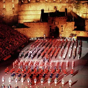
This image depicts a black and white line drawing of the street map of Edinburgh, the capital city of Scotland. The map is quite detailed, showing the intricate network of streets, roads, and intersections that make up the urban landscape. Notable are the dense grid patterns in some areas indicating more developed or residential zones, contrasted with more open spaces which could represent parks or less densely built regions. The latitude and longitude coordinates provided at the bottom (55° 57' 11" N 3° 11' 20" W) give an exact geographical reference for Edinburgh's location on Earth. This type of map might be used for various purposes including urban planning, navigation aids for residents and visitors alike, or educational tools to understand city layouts.
MADE IN THE UK
Safe Shipping with 30 Day Money Back Guarantee
FREE PERSONALISATION*
We are proud to offer a range of customisation features including Personalised Captions, Color Filters and Picture Zoom Tools
SECURE PAYMENTS
We happily accept a wide range of payment options so you can pay for the things you need in the way that is most convenient for you
* Options may vary by product and licensing agreement. Zoomed Pictures can be adjusted in the Basket.